
- Problem: Data alone is nearly useless.
- Solution: Analyze for actionable intel.
- Benefit: Decrease costs, increase crew safety, improve bottom line.
It’s a Tuesday morning and your pipeline integrity team is preparing for another round of scheduled walkover surveys. They’re armed with clipboards, detector equipment, and a nagging awareness that they’re probably missing something: a slow methane seep developing under a new housing development, an encroachment creeping over a high-pressure main, a section of aging iron pipe quietly leaking beyond what the model predicts. Sound familiar?
For Great Britain’s Gas Distribution Networks (GDNs), the gap between what you can see and what is actually happening across 280,000 km of network isn’t just an operational frustration. It’s a regulatory liability, an environmental exposure, and in the case of third-party interference with high-pressure mains, a public safety risk. The smartest operators in the sector are asking a bigger question: what if infrastructure monitoring wasn’t a field-by-field maintenance task, but a continuous, satellite-informed intelligence capability?
The Stakes Are Significant
Leakage forms the majority of every GDN’s business carbon footprint and accounts for approximately 1% of Great Britain’s total greenhouse gas emissions. Despite the Iron Mains Risk Reduction Programme (IMRRP), which has replaced an average of more than 3,000 km of iron pipes per year and driven a 50% reduction in network methane emissions since 2000, gas leakage from distribution infrastructure still amounts to roughly 6% of the UK’s total methane emissions, making GDNs a primary focus of the UK’s Methane Action Plan.
The financial exposure is equally material. Under the RIIO-GD3 price control (April 2026 to March 2031), Ofgem has committed £5.9 billion to replacing a further 16,978 km of iron mains — the final stages of the IMRRP. GDNs that cannot demonstrate proactive leakage detection, accurate shrinkage accounting, and robust encroachment management face scrutiny under the shrinkage incentive mechanisms embedded in the RIIO framework, where gas lost to leakage is a direct cost. Meanwhile, any unplanned gas supply interruption carries customer compensation obligations: £70 per domestic household for every 24 hours off-gas, with businesses entitled to £120 per 24-hour period — and costs escalating the longer the outage runs.
From Scheduled Surveys to Continuous Intelligence
Satelytics is not simply in the business of providing data. The platform delivers intelligence: the difference between knowing an asset exists and knowing its current condition, its risk trajectory, and what action is needed now versus next quarter.
Applying GeoAI to satellite imagery, multi-spectral sensor data, and spatial analytics, Satelytics analyses pipeline corridors across entire network footprints at a fraction of the cost of ground-based survey cycles. For UK gas networks, the most immediate applications are:
- Methane Emissions Quantification: Satelytics’ methane measurement capability identifies and quantifies fugitive emissions in their infancy, enabling GDNs to prioritise repairs before gas losses accumulate. Under RIIO-GD3, GDNs are required to demonstrate active use of Advanced Leakage Detection (ALD) techniques to improve leakage sensitivity beyond traditional surveying. Satellite-based methane sensing is precisely the kind of proactive, technology-led approach Ofgem is seeking to incentivise.
- Encroachment and Third-Party Interference Detection: Third-party dig damage is one of the most consequential risks to gas network integrity and public safety, regulated under the Pipelines Safety Regulations 1996 and the Gas Safety (Management) Regulations as amended in 2023. Satelytics identifies unauthorised activity and encroachments (buildings, structures, or excavations encroaching on pipeline easements) before damage occurs, providing GDNs with the evidence base to take enforcement action and fulfil their duty-of-care obligations.
- Condition-Based Prioritisation for Mains Replacement: The IMRRP has made enormous progress, but with HSE’s review finding that pipe failure rates per kilometre of remaining iron mains are increasing slightly as the higher-risk sections remain, the need for more sophisticated risk prioritisation is acute. Satelytics’ corridor analytics can cross-reference surface movement, soil moisture change, and land-use change data with iron mains asset records to identify the highest-risk segments ahead of the next planned replacement cycle.
- Water Quality and Environmental Compliance Monitoring: Gas infrastructure corridors cross watercourses, flood plains, and ecologically sensitive land throughout Great Britain. Satellite-based water quality monitoring enables GDNs to detect contamination events early and demonstrate environmental stewardship to Ofgem and the Environment Agency.
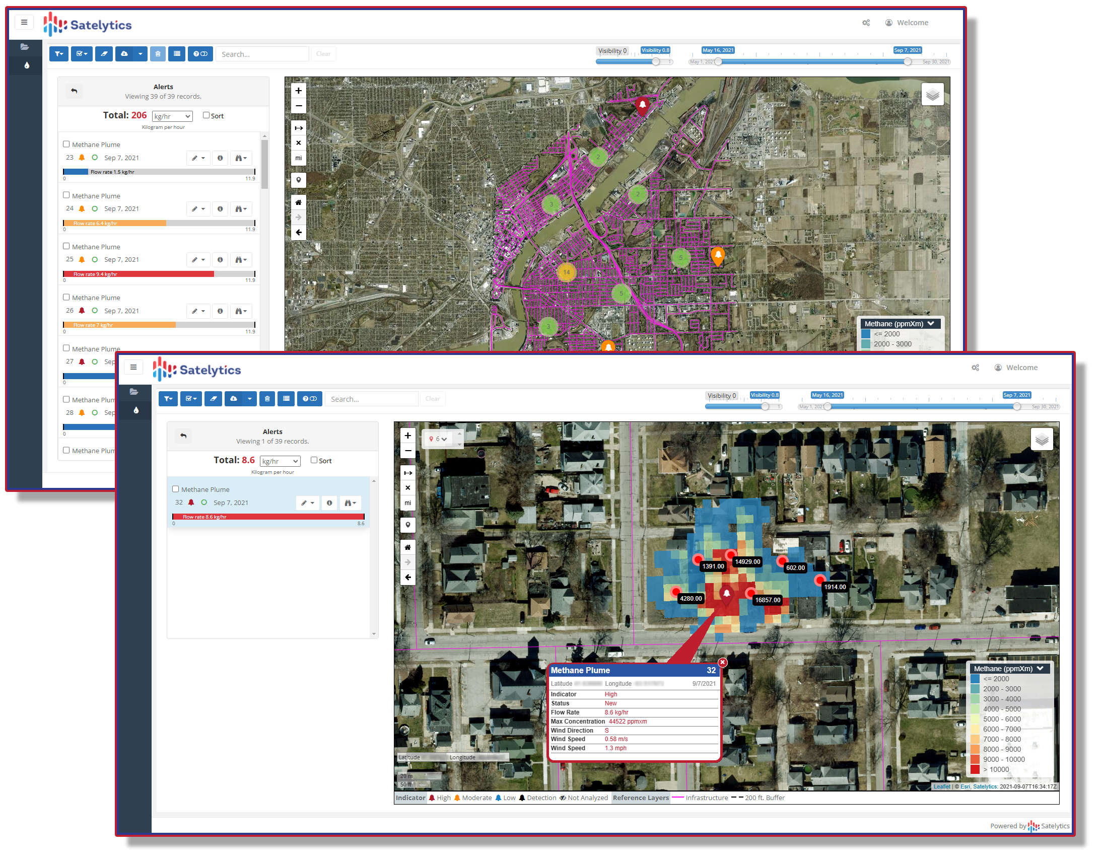
Measure methane emissions.
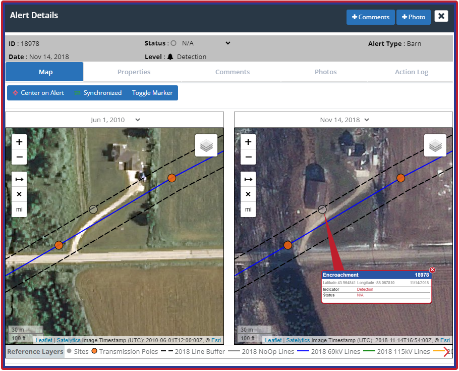
Encroachment alerts made easy.
The Regulatory Imperative Behind the Pipeline
Senior GDN leaders operate at the intersection of several overlapping regulatory obligations that geospatial intelligence can help them meet with greater precision and at lower cost:
RIIO-GD3 Shrinkage and Leakage Incentives — Ofgem’s price control framework incentivises GDNs to reduce methane leakage below baseline targets, with financial rewards for outperformance and penalties for under-delivery. In RIIO-GD2, leakage reduction of approximately 485 kilotonnes of CO₂e was targeted across the period, and RIIO-GD3 targets are expected to be no less demanding. Satellite-derived methane measurements reduce the uncertainty in leakage models and give network operators an early-warning system rather than a retrospective accounting exercise.
Guaranteed Standards of Performance (GSoPs) — Citizens Advice analysis found that electricity and gas networks collectively failed to pay out over £4.5 million in owed compensation in the four years to 2021/22, with gas network pass rates on individual standards ranging from 64% to 98%. A proactive monitoring capability that prevents unplanned interruptions before they trigger GSoP clock-starts is worth quantifying in hard financial terms.
HSE Oversight of the IMRRP — HSE’s enforcement policy for the Iron Mains Risk Reduction Programme runs through 2026 and beyond, with expectations of continued compliance with replacement schedules and leakage management on all remaining iron mains, not just those formally “at risk”. Satellite surveillance of pipeline corridors provides the continuous oversight that periodic walkovers cannot.
A Single Dataset, Multiple Returns
The same satellite pass that monitors methane plumes over your distribution network can simultaneously audit contractor work completion against invoiced tasks, flag third-party encroachments in real time, and detect surface changes indicative of ground movement or subsidence along aging metallic infrastructure. This is not a technology experiment. It is the kind of enterprise intelligence platform that answers to the Operations Director, the Sustainability Lead, the CFO, and the regulator at the same time.
Great Britain’s gas networks are in the final decade of the most significant infrastructure replacement programme in the industry’s modern history. The networks that capture the most value from that investment will be those that pair physical asset renewal with continuous geospatial intelligence — moving from reactive call-outs and scheduled surveys to condition-based, satellite-informed decisions.
Ready to see the full picture? Contact Satelytics to discover how we can turn your network’s pixels into provable performance under RIIO-GD3 and beyond.