
- Problem: Data-driven oil palm farming.
- Solution: Granular data.
- Benefit: Accurate monitoring, reduced fertilizer cost, maximized yields.
Indonesia and Malaysia together account for more than 70% of global palm oil output, with Indonesia alone producing roughly 46 million tonnes and Malaysia adding another 19.4 million tonnes, according to recent USDA data. Behind these headline volumes sits an industry managing tens of millions of hectares of trees planted across remote, tropical, and often disputed terrain — a scale that traditional ground scouting and manual leaf sampling were never built to handle efficiently.
This is precisely the gap that satellite-based geospatial analytics is built to close. Satelytics has already begun applying its algorithm suite to oil palm plantations, combining tree counting, health assessment, height measurement, and nitrogen content analysis into a single monitoring system currently active over plantations in Malaysia. The same underlying technology stack that Satelytics built for utility vegetation management and pipeline right-of-way monitoring translates directly onto the palm frontier, where the problems are strikingly similar in shape: sprawling linear or areal assets, expensive field labor, and consequences that compound quickly when problems go unnoticed.
Vegetation Management: Seeing Every Tree, Not a Sample
Traditional plantation inventory relies on sample blocks and extrapolation. Satelytics inverts that model by analyzing entire plantation footprints simultaneously using high-resolution multispectral imagery, typically at 30-centimeter resolution (about the size of a dinner plate) to detect and count individual oil palm trees with precision. That per-tree resolution matters economically: aging palms are a documented drag on yield, with one Malaysian study estimating that crop ageing alone caused a minimum opportunity loss of RM 1.49 billion in 2020. Knowing the exact age structure and productivity potential of every palm in a concession, rather than a sampled subset, turns replanting and thinning decisions from guesswork into scheduling.
Tree health is assessed through spectral signatures invisible to the naked eye. Oil palms under stress exhibit chlorosis and other symptoms that Satelytics’ vegetation algorithms detect before they become visible during routine field walks. This early-warning capability is especially valuable against Ganoderma basal stem rot, the most economically damaging disease in Malaysian and Indonesian plantations. Ganoderma infection rates between 31% and 67% have been linked to fresh fruit bunch (FFB) yield drops of 26% to 45% in affected plantations, and another study found that economic losses from the disease can reach up to 68% of attainable yield on infected palms. Because Ganoderma often shows no external symptoms until the infection is advanced, remote sensing research has focused for nearly two decades on catching the disease at the spectral level.
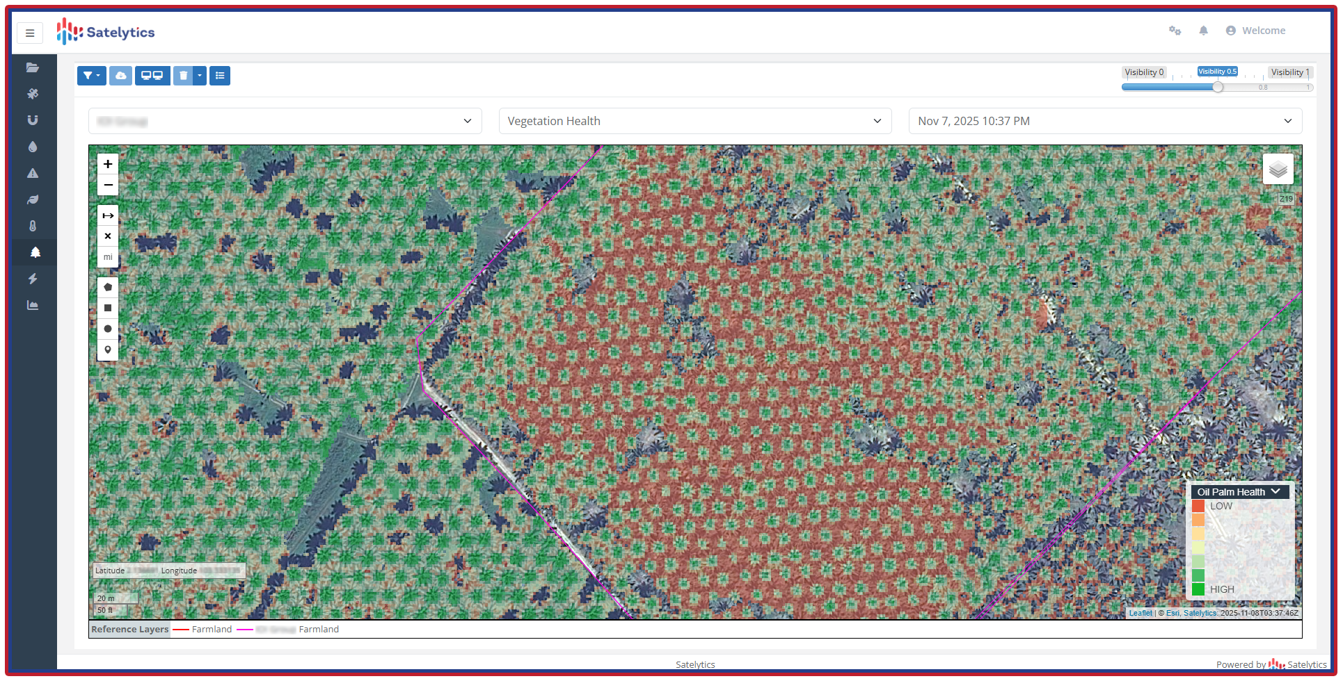
Oil palm health measured.
Height measurement rounds out the vegetation picture. Satelytics’ satellite-based approach delivers tree height readings within 5% of actual field measurements, trading a small amount of vertical precision (relative to LIDAR) for dramatically greater coverage, frequency, and cost efficiency across an entire plantation.
Land and Water Chemistry: Nitrogen Without the Ladder
Foliar nitrogen analysis is the backbone of fertilizer decision-making in oil palm, but the conventional process is manual, destructive, and thin on coverage. Agronomic guidance calls for leaf sampling from every manuring block at least once a year, with bimonthly or quarterly sampling recommended where seasonal nutrient variation is unknown. Each sample carries a real cost: Malaysian Palm Oil Board pricing lists foliar chemical analysis at RM 200 per sample and soil analysis at RM 350 per sample, with full agronomic advisory service starting at RM 2,000 per 30 hectares. Scaled across a plantation measured in tens of thousands of hectares, that sampling regime becomes a significant recurring line item, and it still only characterizes a small fraction of the trees actually growing there.
Satelytics’ capability to measure nitrogen content directly in palm fronds from satellite imagery represents a structural departure from that approach. Rather than climbing trees, cutting frond samples, and extrapolating nutrient status across an entire block, operators receive nitrogen readings at the level of individual palms, across the whole plantation, on whatever cadence the imagery allows. That shift matters because fertilizer is one of the largest controllable input costs in palm cultivation. The spectral-fingerprint approach gives plantation managers an unprecedented view of nutrient depletion and contamination risk across the property, complementing the frond-level nitrogen signal with a ground-level chemical baseline.
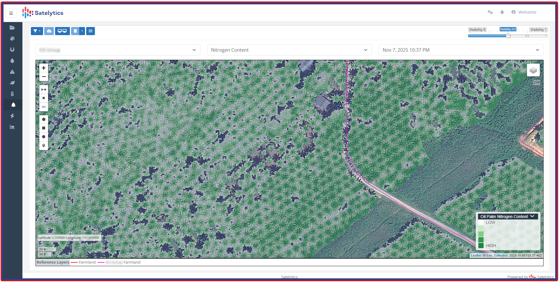
Oil palm foliar nitrogen analysis.
Encroachment Detection: A Legal and Financial Fault Line
Nowhere is geospatial monitoring more valuable to a plantation operator than at the property boundary. Large concessions in Indonesia and Malaysia routinely span tens of thousands of hectares of remote terrain, and boundary lines that run for dozens of kilometers through forest and smallholder-adjacent land are effectively impossible to patrol on foot with any regularity. Into that gap step third-party encroachers: smallholders expanding informal plots, opportunistic loggers, illegal miners, and organized actors planting or harvesting fruit on land that belongs to the concession holder.
A prior academic mapping study of Central Kalimantan alone identified an estimated 859,600 hectares of illegal palm cultivation spread across conservation forest, production forest, and protected peatland categories, with over 620,000 hectares attributed to cultivation operating without any permit. This scale of unauthorized activity translates directly into stolen fruit, disputed yield, and boundary lines that erode a little more every harvest season.
Satelytics’ Constant Vigilance™ change-detection algorithms, with results delivered just hours after satellite overpass, deliver continuous, dated, geolocated imagery flagging new clearing, unauthorized structures, foot traffic, or harvesting activity along the boundary as it happens, rather than weeks or months later.
For plantation owners and operators, early detection converts a slow-motion property loss into an actionable, time-stamped record. Geolocated before-and-after imagery gives security teams and legal counsel precise coordinates to dispatch personnel, a documented timeline to support eviction or prosecution proceedings, and evidence that stands up in negotiations with encroaching parties or in court.
Satelytics also protects certification status and buyer relationships. RSPO-certified operations and downstream buyers increasingly require documented proof that a plantation’s boundaries and supply chain are free of undocumented third-party cultivation. Continuous monitoring provides that proof as a byproduct of routine surveillance rather than a separate compliance exercise. In a region where a single unpatrolled kilometer of frontage can be worth thousands of tonnes of fruit over a few years, satellite-based perimeter monitoring turns encroachment from an inevitability into a manageable, defensible line item.
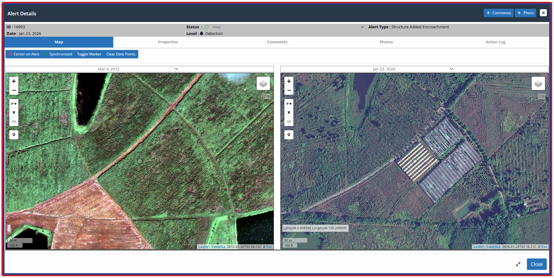
Encroachment alerts can indicate unwanted activity.
Storm Damage Assessment: Quantifying Losses Before the Insurance Call
Weather volatility is a recurring and measurable threat to plantation revenue. The operational question is the same regardless of cause (flood, wind, or drought): Which blocks are damaged? How severely? and Where should recovery crews and replanting budgets go first? Satelytics’ change-detection framework, which already compares before-and-after imagery to verify vegetation cover and height changes in utility settings with up to 90% field-confirmed accuracy, is directly applicable to post-storm triage. We replace a slow, ground-based damage survey across thousands of hectares with a rapid, imagery-based map of exactly where fronds are down, canopy is thinned, or entire blocks are compromised.
Bringing It Together
The through-line across all four capability areas (vegetation health, land and water chemistry, encroachment, and storm damage) is that Satelytics offers them all from the same underlying satellite dataset for a single acquisition cost, an approach already proven across more than 40 algorithms in the utility and pipeline sectors. For an oil palm operator facing regulatory scrutiny on one side, disease and nutrient management on the other, and unpredictable weather threading through both, that consolidation is the practical advantage: one set of imagery, refreshed on whatever cadence the operation requires, answering questions that would otherwise demand separate ground crews for boundary surveillance, leaf sampling, disease scouting, and storm assessment.
The oil palm operators who can see their entire plantation — every palm, every border, every chemical signature — at once will be the ones making better, profit-maximizing decisions with data instead of extrapolation.