
- Problem: Gas storage risk extends far.
- Solution: Multilateral approach to MVA.
- Benefit: Overlapping lines of evidence, defensible facility records.
Salt caverns are the sprinters of underground natural-gas storage. A typical facility can deplete working gas in about 10 days and refill in about 20, compared with a roughly 150-day withdrawal season for depleted fields and aquifers. EIA has also reported that salt facilities can cycle as many as 12 times per year. In 2015, they represented only 10% of Lower 48 storage capacity but 28% of daily deliverability.
That flexibility creates enormous value. It also means repeated pressure, temperature, injection, and withdrawal changes acting on cavern walls, wells, piping, compressors, and brine systems. The operating question is: “Can the operator recognize abnormal behavior wherever it appears and prove what happened next?”
Rare Does Not Mean Small
Salt is highly impermeable and mechanically self-sealing, but storage systems include much more than salt. Casings, cement, wellheads, valves, gathering lines, legacy wells, and surface equipment create credible pathways for loss of containment. PHMSA counts approximately 36 U.S. underground natural-gas salt-cavern facilities and regulates them under 49 CFR 192.12, which incorporates API RP 1170 into the federal safety framework.
History shows why surveillance cannot stop at the fence. In 2004, a well-control incident at the Moss Bluff salt-cavern facility released and burned approximately 6 billion cubic feet of gas over six and a half days. In 2001, gas from the Yaggy storage field migrated about nine miles underground, surfaced through old brine or salt wells in Hutchinson, Kansas, damaged businesses, and killed two people.
Aliso Canyon was not a salt cavern, but it makes the atmospheric point just as forcefully. The 112-day blowout released nearly 100,000 metric tons of methane, and later remote-sensing reconstruction found plume influence at least 6.2 miles downwind. A property boundary is an administrative line, not a scientifically defensible monitoring boundary.
One Risk, Three Views
No single sensor can provide complete monitoring, verification, and accounting (MVA). A methane image can identify gas in the atmosphere but cannot show whether the ground is shifting. Radar can measure surface displacement but cannot confirm that the moving material is methane. Vegetation imagery may reveal a small, persistent seep that falls below direct-detection conditions, but plant stress can also result from drought, disease, salinity, or drainage.
That is precisely where Satelytics’ multilateral analytics model fits. Satelytics assembles multiple geospatial measurements into one operating picture and delivers mapped, actionable alerts through a common environment. Its Constant Vigilance™ approach is designed to run multiple analyses over shared imagery and asset geography, reducing duplicated acquisition and giving operations, integrity, environmental, and compliance teams the same evidence base.
For salt-cavern MVA, three sensing layers are especially powerful:
- SWIR sees the gas. Methane absorbs shortwave infrared light at distinctive wavelengths. Satelytics analyzes high-resolution shortwave infrared (SWIR) imagery with meteorological data to locate plumes, estimate concentration gradients, calculate flow rates, and guide crews toward probable sources. Its published methane workflow produces GPS coordinates and estimated flow within hours of imagery becoming available. Satelytics analyzes7-meter imagery and delivers a minimum detection threshold of 1 kilogram per hour under optimal conditions. This supports detection at wells, compressors, valves, dehydrators, meters, tanks, and connecting pipelines and helps distinguish the operator’s plume from nearby industrial or biological sources.
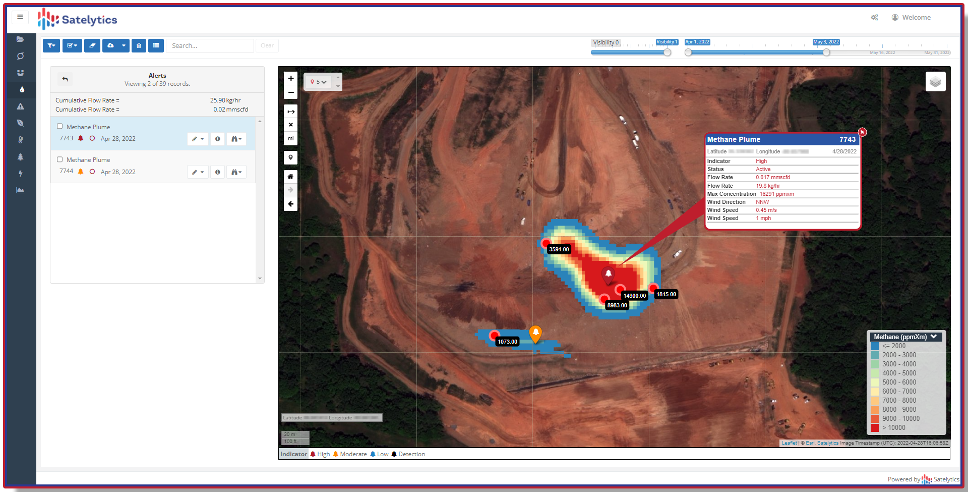
Measure methane releases.
- InSAR sees land movement. Interferometric synthetic aperture radar (InSAR) compares repeat radar observations to measure subtle displacement across the cavern field. Satelytics can use these time series to map long-term subsidence, seasonal “breathing,” acceleration, and differential movement around wells, roads, foundations, berms, and pipelines. Correlating those patterns with cavern pressure and injection-withdrawal cycles can identify behavior that deserves targeted geotechnical review.
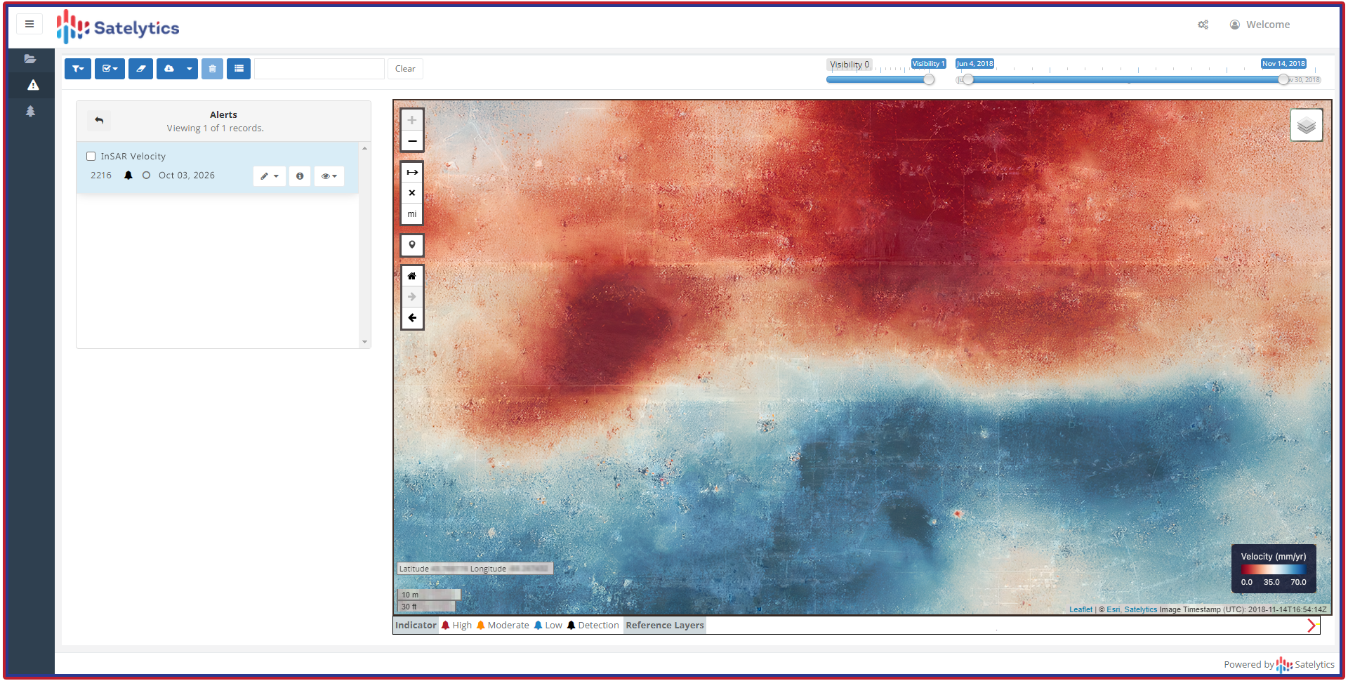
Measure land deformation.
- NIR sees the response. Small or diffuse subsurface seeps may not always create a directly measurable atmospheric plume during a satellite pass. Escaping gas can alter soil oxygen and stress vegetation, changing its near-infrared (NIR) reflectance before damage becomes obvious to the eye. Controlled research found gas-related vegetation stress detectable after roughly three weeks, with decreased NIR reflectance; other work found significant spectral changes after only three days. Satelytics can use NIR-based vegetation analytics as a persistent screening layer around wells, legacy pathways, pipelines, and the projected cavern field.
NIR is not a methane detector, and a stressed plant is not proof of a leak. Its value is as a corroborating or triggering signal: an unexplained pattern can direct soil-gas sampling, leak surveys, groundwater testing, or well-integrity investigation. When a vegetation anomaly aligns with a SWIR plume, ground movement, operating upset, or known migration pathway, confidence rises. When layers disagree, they show where more evidence is needed.
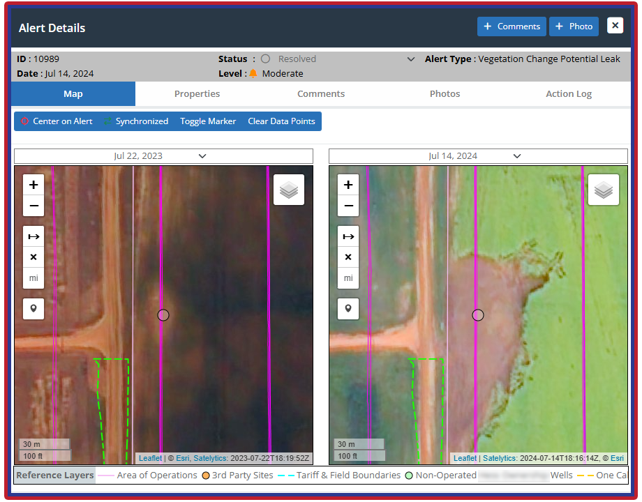
Infer small gas leaks via surrogate vegetation indicators.
From Monitoring to Proof
The multilateral approach strengthens all three parts of MVA.
- Monitoring establishes recurring, area-wide awareness of methane, deformation, vegetation health, environmental change, and asset activity.
- Verification compares geospatial alerts with weather, SCADA, pressure, inventory, inspections, work orders, and field measurements—and then reobserves the site to confirm that corrective action worked.
- Accounting combines measured flow with a defensible event-duration range, operating records, repeat observations, and uncertainty to estimate released mass.
A satellite overpass is a snapshot, not an annual emissions ledger. EPA’s Greenhouse Gas Reporting Program includes underground natural-gas storage under Subpart W. Covered facilities must calculate applicable emissions and retain supporting records. OGMP 2.0 similarly treats its highest reporting level as reconciliation between source-level inventories and independent site-level measurements. A Satelytics event record can preserve the alert, coordinates, imagery, estimated flow, confidence, field findings, repair, reobservation, and closure status as one auditable chain.
Watch the Ground Breathe
Deformation makes this more than a methane program. At Germany’s Gronau-Epe cavern field, analysis of weekly Sentinel-1 scenes from 2015 through 2021 found vertical movement as large as 240 millimeters and classified horizontal movement across 71 caverns. Those measurements do not prove cavern failure. They show that broad, repeated radar observations can reveal patterns that sparse monuments may miss and can focus experts on the right wells, structures, roads, or pipeline crossings.
The same principle applies to vegetation. A chronic microseep may leave a cumulative biological signature even when atmospheric detection conditions are unfavorable. Conversely, a large release might appear clearly in SWIR before vegetation responds. The strength is not any single layer; it is the temporal and physical complementarity among them.
Monitor the System
A 10-by-10-kilometer area of interest (our minimum purchase for satellite imagery) may look oversized if the assignment is “scan the well pad.” But it is perfectly appropriate when the assignment is “observe the storage system.” That footprint can include the cavern array and salt-dome projection, wells and gathering lines, brine assets, downwind plume space, legacy wells, drainage, nearby communities, adjacent methane sources, and stable reference terrain needed for InSAR.
The area need not be square. It can follow prevailing winds, a linear cavern field, groundwater flow, connecting pipelines, or sensitive receptors. Satelytics’ sensor-agnostic, multilateral model is well suited to this design: match the sensor to the phenomenon, process the evidence in one analytics environment, and assign alerts to the people responsible for acting.
Salt-cavern storage earns its value through speed. Its assurance program should do the same. Satelytics offers operators more than another methane map: it offers overlapping SWIR, InSAR, and NIR intelligence that can find change, direct investigation, verify results, and document performance across the entire area that matters. That is complete MVA; not because one sensor sees everything, but because multiple sensors make it harder for important change to remain unseen.