
- Problem: Wise use of unspent budget.
- Solution: Pilot now, budget expansion next year.
- Benefit: Validate value quickly, scale with confidence.
Every fourth quarter, the same conversation surfaces inside utilities, oil and gas companies, and pipeline operators: What remains in the budget, what can still be put to useful work, and what will next year’s funding look like?
There is nothing inherently strategic about spending money simply because the calendar says to do so. In fact, research on expiring public-sector budgets found that year-end spending surged while the quality of technology projects declined: a useful warning against buying something merely to clear an account. But allowing available funds to disappear without investigating a high-value operational question may be a missed opportunity, too.
A better Q4 question than “What can we buy?” is, “What uncertainty can we remove before planning is locked?”
For operators responsible for widespread, difficult-to-inspect assets, a focused geospatial analytics (GeoAI) pilot can provide an unusually practical answer. It can turn a modest year-end allocation into evidence about what can be detected, how quickly teams can respond, how the information fits existing workflows, and where a broader program could create value next year.
Two Budgets, One Decision
Year-end planning often treats this year’s remaining funds and next year’s proposed budget as separate matters. They should be connected.
A Q4 pilot can inform a 2027 budget request with results from the operator’s own assets, terrain, weather, priorities, and field teams. At the same time, placing a larger GeoAI initiative into next year’s budget creates a path to scale if the pilot succeeds. The organization is no longer asking leadership to fund a promising idea. It is asking leadership to extend a tested capability.
That distinction matters. A proof of concept is most useful when it tests a new technology in a realistic environment before more substantial financial and human resources are committed. Good pilot practice calls for clearly defined goals, scope, evaluation methods, and success criteria so the outcome supports a sound deployment decision.
In other words, “let’s try geospatial analytics” is not a plan. “Let’s determine whether GeoAI can identify actionable vegetation encroachments across our highest-risk transmission corridor and deliver alerts our field organization can validate within an agreed response window” is.
A Pilot, Not a Science Project
GeoAI has matured well beyond an interesting image on a screen. Satelytics applies AI-powered algorithms to imagery to identify physical, chemical, and biological changes, including methane emissions, liquid releases, vegetation conditions, land movement, erosion, and third-party encroachments, then directs users to the location and severity of identified concerns.
The purpose of a Q4 pilot is not to explore every possible application. It is to select one consequential business problem, test it over a meaningful area, and learn fast enough to shape the next decision.
A strong pilot can be framed around four elements:
- A specific operational question. Choose a challenge with a clear owner: leak detection, methane monitoring, vegetation management, geohazards, right-of-way change, or another persistent risk.
- A representative test area. Select assets with known conditions, credible field history, or elevated exposure; not an easy location designed only to produce an attractive result.
- Agreed success measures. Decide in advance what matters: detection relevance, location accuracy, alert timeliness, field-verification rate, workflow fit, or the ability to prioritize limited inspection resources. Let us help with lessons learned from numerous other customers.
- A scale-up decision. Define what evidence would justify expansion, modification, or a no-go decision in 2027.
Satelytics’ own proof-of-concept guidance follows a similar logic: define the business challenge, determine the appropriate monitoring frequency, and begin with a targeted area where key performance indicators and response processes can be evaluated before scaling.
Learn on Real Assets
The value of a pilot is not theoretical. One of the U.S.’s largest utilities used a Satelytics pilot to evaluate satellite-based monitoring for construction encroachments along electric transmission corridors. High-resolution imagery was analyzed quarterly, alerts were compared with field observations, and operational feedback was used to refine the analytics. By the end of the pilot, alerts were focused on encroachments that presented a safety concern or operational problem, while results could be transferred into the utility’s Esri ArcGIS environment.
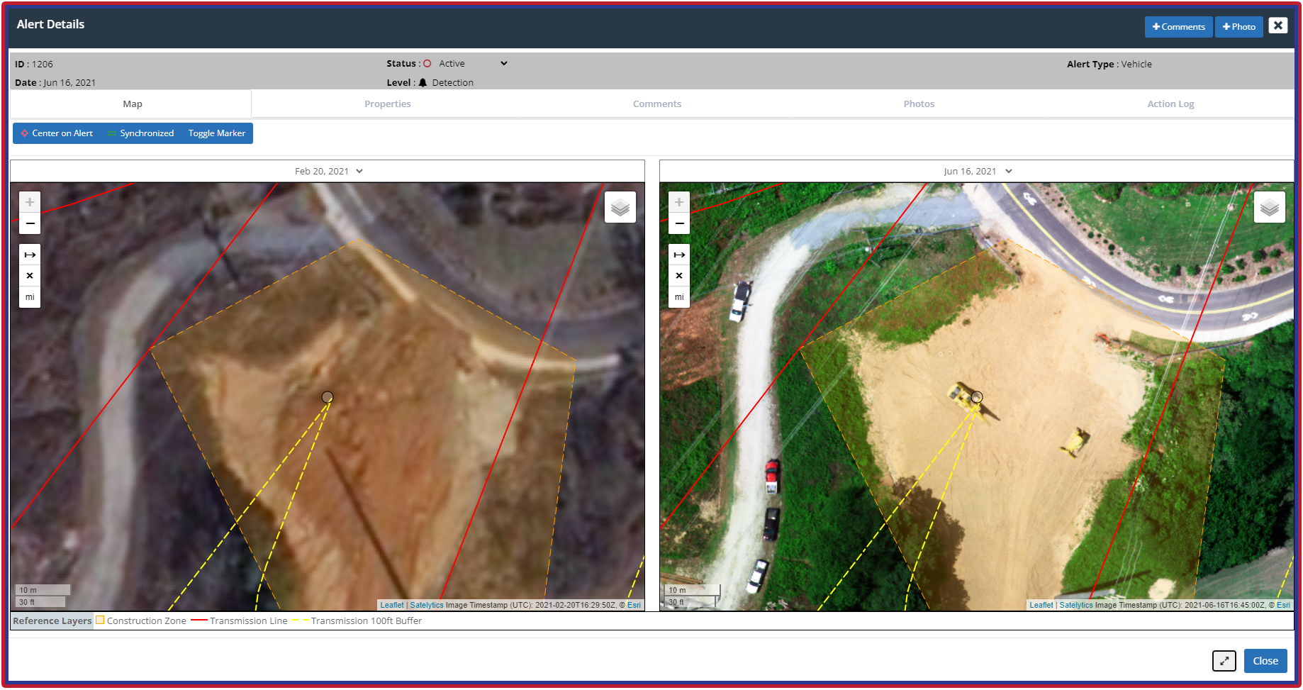
Construction encroachments along electric transmission corridors.
That is what productive experimentation looks like. The technology is evaluated, but so is the organization around it. Who receives an alert? Who validates it? What creates a work order? Which findings demand immediate action? What information belongs in GIS, asset management, or compliance systems? A well-executed pilot program exposes these questions while the scope is manageable.
It also helps teams avoid a common trap: budgeting only for technology and not for adoption. A 2027 GeoAI budget should consider the operating cadence, imagery requirements, analyses to be performed, user access, integrations, field-validation effort, governance, and the internal owner responsible for converting alerts into action.
Put Q4 to Work
October may feel late to investigate a new monitoring approach, but the first step is not an enterprise rollout. It is a scoped conversation.
Start with the asset and the decision, not the sensor or observation platform. Identify the recurring problem that consumes inspection time, creates blind spots, increases risk, or arrives as a surprise. Bring operations, integrity, environmental, GIS, innovation, and procurement stakeholders into the discussion early enough to define a credible pilot. Then determine whether available 2026 funds can support initial imagery, analytics, configuration, and validation activities.
Even when contracting or seasonal conditions limit how much can be completed before December 31, work begun now can still be valuable. Scoping the geography, confirming available imagery, assembling GIS layers, selecting analyses, defining success measures, and reserving funds can shorten the path to results. Just as important, the planning process creates a defensible basis for a larger 2027 line item.
The goal is not to manufacture a reason to spend. It is to use available budget deliberately to reduce uncertainty, test operational value, and enter next year with more than a concept.
Budget for What Comes Next
A successful pilot should answer three questions:
- Did the analytics find information the organization could act on?
- Did that information improve the way people prioritized or performed work?
- Is the value likely to grow when coverage, frequency, or use cases expand?
If the answers are encouraging, the next-year budget should not begin from zero. It should reflect the lessons of the pilot and provide room for broader geography, more frequent monitoring, additional algorithms, workflow integration, and change management. Because multiple analyses can often be applied to the same imagery, a program that begins with one use case may reveal a practical path toward wider asset vigilance.
Q4 is a narrow window, but it can open a much larger one. Investigate GeoAI options now. Use remaining funds for a focused, measurable pilot where they can produce real operational learning. And protect space in the 2027 budget to scale what works.
The budget clock is running. The better reason to act is that the learning clock is, too.