
- Problem: Monitoring vast assets.
- Solution: Direct resources to priorities.
- Benefit: Faster awareness & correction, less scouting missions, lower costs.
There is a point at which an inspection problem becomes a geography problem. The United States has 3.3 million miles of regulated pipeline, including 2.3 million miles of gas distribution infrastructure, while the contiguous electric transmission system includes roughly 526,000 circuit-miles at 69 kV and above. No organization can place an inspector beside every mile, shoreline, reservoir, ranch, well pad, or development site every day.
Traditional patrols remain indispensable, but each method samples the world differently. Foot and vehicle patrols provide context but cover limited ground. Aircraft cover more territory at higher mobilization cost. Drones provide exquisite local detail but struggle to achieve wide area coverage. The business gap is not a lack of capable patrol methods. It is the inability to apply them everywhere, often enough, without exhausting budgets and people.
Frequency matters because risk is asymmetric: thousands of unchanged miles consume inspection capacity while one new excavation, stressed slope, leaking fitting, or fast-growing tree can dominate the consequence. Effective monitoring must therefore separate “no change” from “needs attention” quickly.
That gap explains the business challenges for which Satelytics is most often contracted. Pipeline liquids, methane, algae, trees, landslides and weeds appear unrelated but share three characteristics: a large area, a condition that produces an observable geospatial signal, and a decision that becomes more valuable when made sooner. The economics strengthen when one image acquisition supports several analyses, spreading the cost of observation across multiple operating departments instead of funding disconnected surveys.
Oil & Gas and Pipelines
Liquid Leak Detection
Liquid leak detection is fundamentally a time-to-awareness problem. Small hydrocarbon or produced water releases may evade balance systems and periodic patrols, particularly on gathering networks. High-resolution spectral analysis can identify surface expressions and distinguish brine-wetted soil or gravel from ordinary water. One 4,000-square-mile monitoring program found a remote leak 13 days earlier than traditional methods would have. It cannot directly see a contained below-grade leak but vegetation stress may provide an indirect signal.
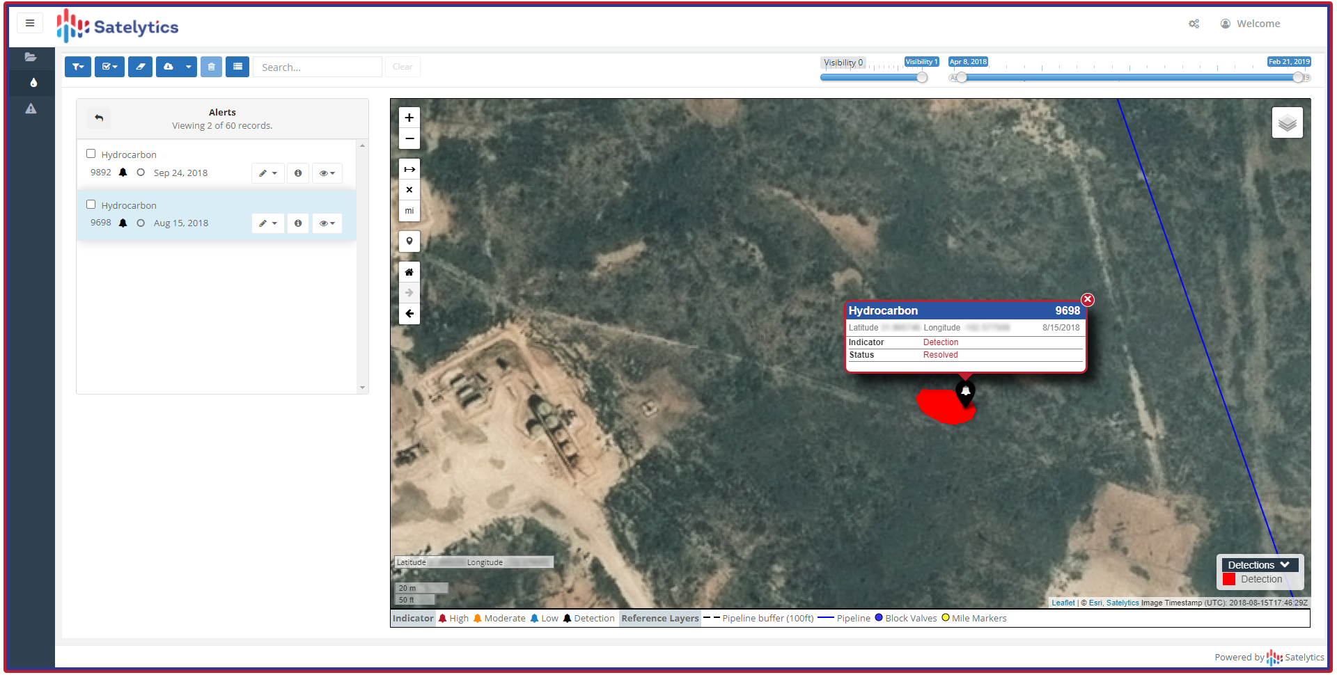
Alerts on small pipeline leaks missed by other methods.
Methane Leak Detection
Methane presents a different requirement: finding a plume is useful, but locating and quantifying the source changes the work order. Satelytics is typically engaged to measure plume concentration and source flow rates down to 1 kg/hr. That threshold is far below the EPA Super Emitter Program’s 100 kg/hr definition, making the business objective routine leak repair rather than merely identifying exceptional events.
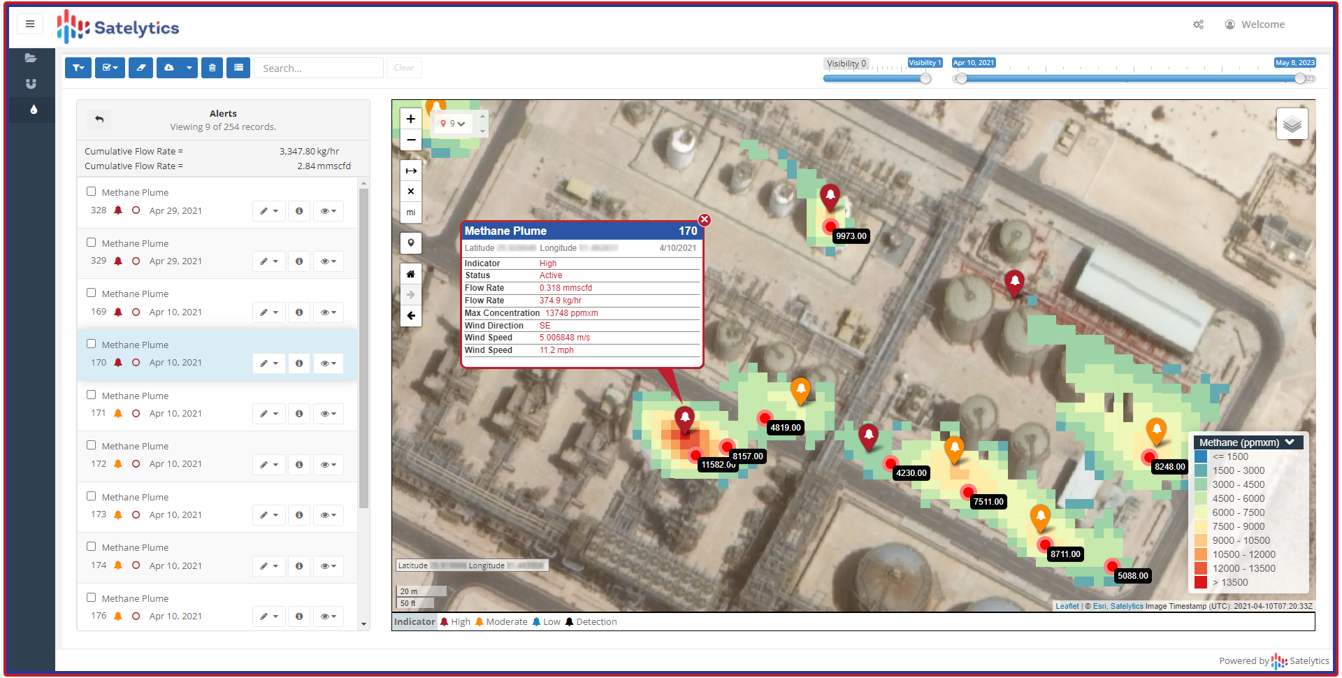
Measure oilfield natural gas emissions.
Land Movement and ROW Encroachment
Land movement and right-of-way encroachment address threats outside the pipe. A 2023 industry framework identified 266 reported pipeline incidents related to geohazards or natural hazards. Landslides were the most prevalent source of ruptures. Excavation damage is also a leading source of life-threatening pipeline incidents. Repeated imagery can reveal slope movement, erosion, new roads, equipment, structures, or excavation, allowing specialists to investigate change rather than repeatedly patrol unchanged miles.
Electric and Gas Utilities
Methane Leak Detection
For gas distribution operators, precise methane location can convert LDAR from “leak detection and repair” into something closer to direct leak repair. The value is not a prettier plume map; it is fewer hours spent searching and a clearer queue of sources to confirm and fix. Geospatial detection complements mobile surveys, handheld instruments, emergency calls, and regulatory-grade field confirmation.
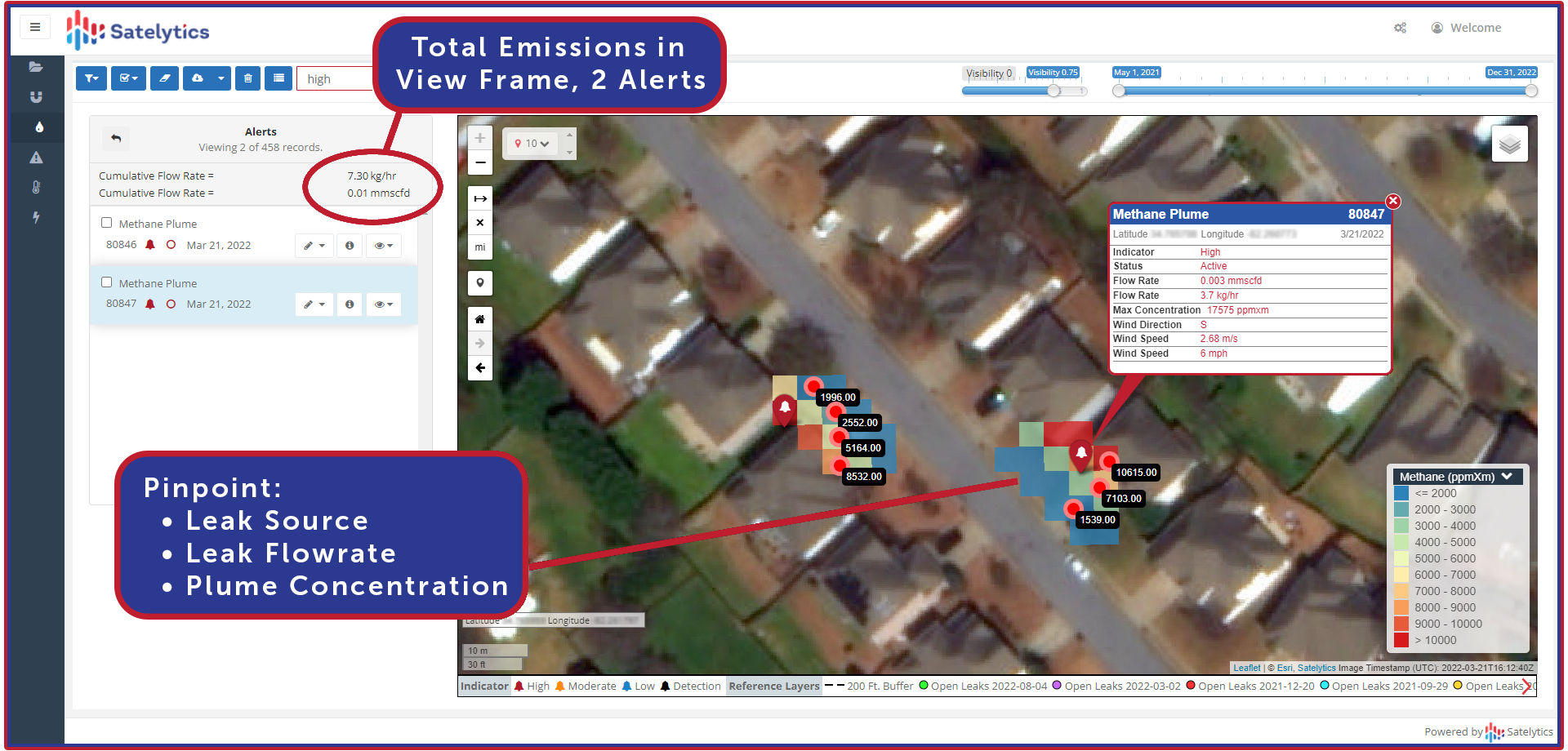
Measure and distinguish multiple tiny gas leaks.
Vegetation Management
Vegetation management illustrates the same shift from calendar-based work to risk-based work. NERC reported 19 transmission outages in 2025 from vegetation outside the right-of-way, 84% associated with weather activity. Circuit-level analysis can rank strike-potential trees, growth, health, and proximity so planners can prioritize near-term hazards while building defensible out-year trim plans. It is especially valuable across vast distribution zones.
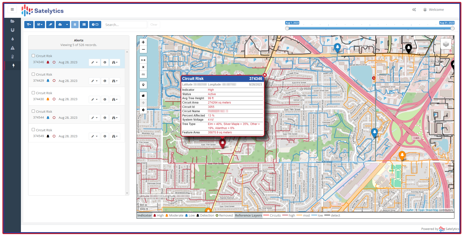
Circuit risk analysis transforms reactive to proactive actions.
Corridor Encroachment
Corridor encroachment turns “we did not know” into an avoidable failure mode. Automated change detection can identify new construction, grading, vehicles, structures, and access roads across the entire easement, then route exceptions to ROW personnel. It strengthens 811, public awareness, and patrol programs; it does not replace them.
Asset Conflation Analysis
Asset conflation analysis solves quieter problems. Asset conflation compares imagery-derived pole and tower locations with GIS records and flags mismatches for correction. Utility guidance documents note that mapped lines and service points can sometimes be hundreds of feet from their true locations, leading to inaccurate assessments of manpower and equipment required for maintenance and flawed assessments of surrounding vegetative threats.
Service Connection Readiness
Construction stage assessment can identify developments that appear physically service-ready, helping utilities focus crews and customer outreach where progress is possible. That matters when energization and gas line connection queues persist. A California legislative analysis found 134 construction-ready projects at one major utility had waited more than eight weeks to be completed, as of February 2023.
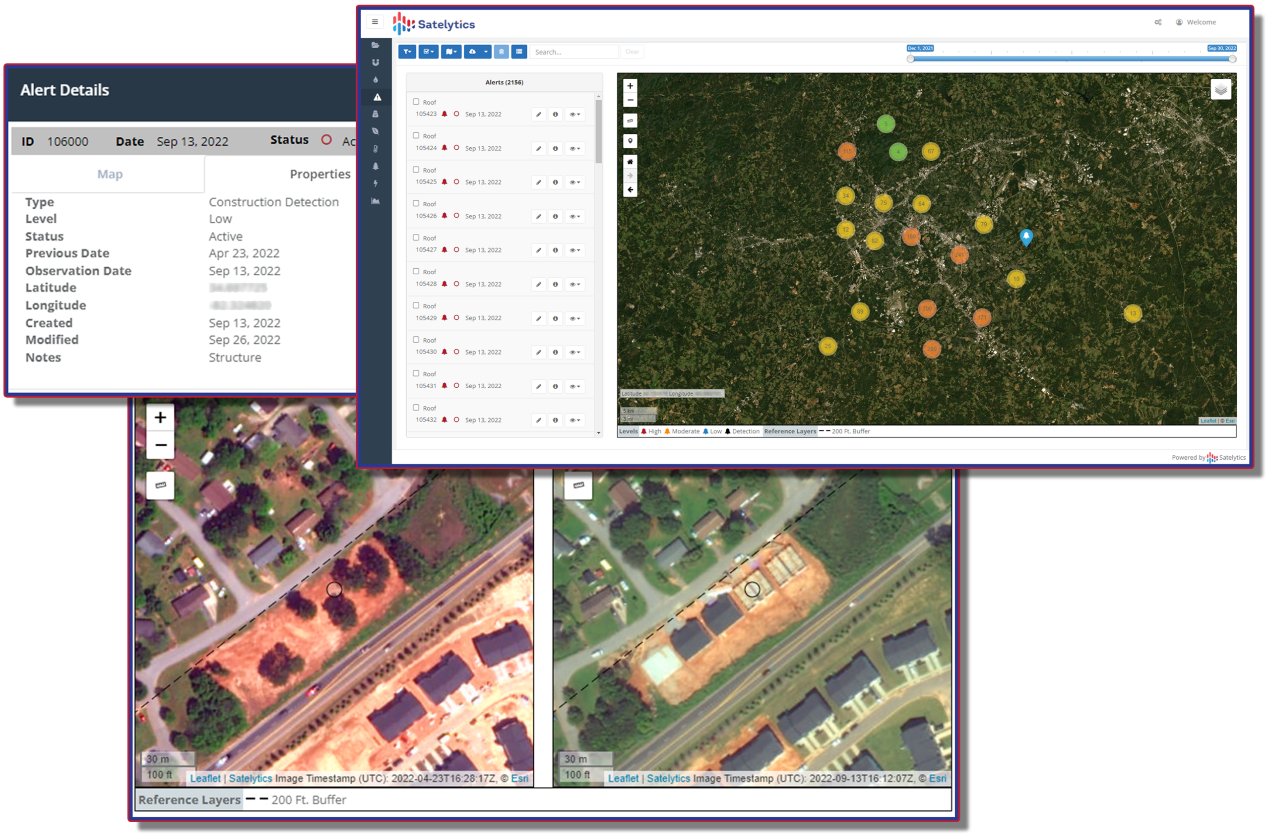
Streamline new utility connections workflow.
Shoreline Monitoring
Reservoir shoreline monitoring applies the same change logic to docks, clearing, roads, structures, and other potentially unpermitted activities. The U.S. Army Corps of Engineers defines encroachments broadly, including buildings, roads, septic systems, fences, and vegetation alteration. Satellites can screen the shoreline consistently while permitting staff stay focused on determining legality, contacting landowners, and inspecting ambiguous cases, thus achieving efficiency by focusing experts on areas requiring their expertise.
Water Resource Management
A drinking water intake is a point. Its watershed is an area. Satellite-derived water quality analytics can extend awareness beyond periodic point samples by mapping nutrients, chlorophyll-related conditions, turbidity, and harmful algal bloom indicators across the full waterbody and watershed. The stakes are tangible: Toledo’s 2014 cyanotoxin event left 500,000 residents unable to drink tap water for three days and was associated with more than $10 million in lost shoreline-property services. Remote measurement is an early-warning and targeting layer.
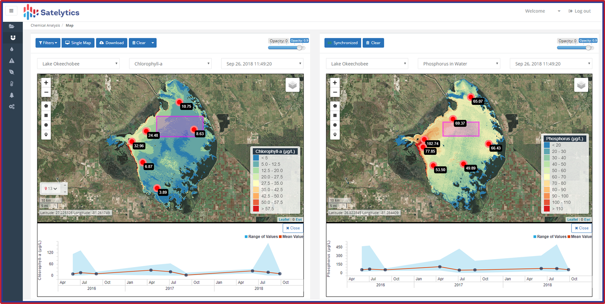
Measure a wide variety of water quality indicators.
Ranching
Ranching has the same scale mismatch. Invasive plants rarely occupy a ranch uniformly, yet blanket treatment assumes they do. USDA guidance reports that dense medusahead infestations can reduce livestock carrying capacity by as much as 70% and emphasizes early treatment while infestations remain small. Species mapping can direct herbicide to priority polygons, reduce unnecessary application, track treatment response, and protect forage and livestock health. The approach is strongest where the target species has a distinguishable spectral and seasonal signature; field confirmation remains prudent where species overlap.
The Fit Test
Satelytics is a strong fit when the business question is, “What changed, where, how much, and what deserves attention first?” It is strongest across large, dispersed territories; with repeatable monitoring; when the target has a visible or spectral expression; and when an alert can trigger a defined operational response. It makes scarce field expertise more productive by replacing blanket patrol with exception-based dispatch.
It is not the right tool for every condition. A small site requiring minute-by-minute alarm coverage is usually better served by fixed sensors or SCADA. A legal determination or ambiguous classification still belongs to qualified people on the ground.
The most useful question, therefore, is not whether satellite-based GeoAI can replace patrols. It should not. The better question is whether every acre and mile needs the same amount of human attention. When geography is vast and change is sparse, the winning operating model is often simple: observe everything consistently, measure what can be measured, and send people where evidence says they are needed.