
- Problem: Moving off business-as-usual.
- Solution: Follow a simple 5-step guide.
- Benefit: ↓Costs, ↓Environmental impact, ↑Compliance.
GeoAI Isn’t the Future. It’s the Standard.
Monitoring thousands of miles of pipeline or right-of-way from space once sounded like science fiction. That era is over. Geospatial analytics (GeoAI), the fusion of satellite imagery and artificial intelligence, has moved from experimental pilot to operational baseline for infrastructure-heavy industries. The market data proves it: the global geospatial imagery analytics market, valued at roughly USD 12.2 – 27.3 billion in 2025, is projected by multiple independent research firms to grow at a compound annual rate ranging from 10% to more than 30% through the early 2030s, with some forecasts putting the 2034 market above USD 300 billion. Satellite data analytics specifically is expanding at roughly 14.2% CAGR as AI models increasingly analyze orbital sensor streams automatically, replacing manual GIS interpretation with cloud-native pipelines.
Orbital infrastructure has scaled just as dramatically. Fewer than 2,000 active satellites existed in 2019. Today, trackers count between 14,500 and 18,600 in orbit, nearly an eightfold increase. Earth observation constellations alone are expected to add about 1,158 new satellites between 2026 and 2029, putting near-daily, high-resolution revisit rates within reach of virtually any organization with physical assets to protect. The imagery exists, constantly and affordably, at resolutions unthinkable a decade ago. The only real question left is whether an organization has the operational discipline to put it to work.
Regulatory pressure makes that question urgent. PHMSA data shows an average of 26 pipeline incidents annually from 2014 through 2024, with no meaningful downward trend despite decades of inspection investment. And that number is only based on PHMSA-regulated pipelines. On the emissions side, the Oil & Gas Methane Partnership’s OGMP 2.0 framework now formally incorporates satellite observation into its methane reporting and reconciliation architecture, pushing operators toward asset-level, source-level quantification that assumes space-based monitoring as a baseline input, not a novelty. Regulators, insurers, and investors are no longer asking companies to consider geospatial analytics. They are beginning to expect it.
Why “Novel Technology” Is the Wrong Framing
Positioning GeoAI as a bleeding-edge experiment undersells it and gives internal skeptics an excuse to wait. Commercial satellite constellations, machine learning trained on millions of labeled anomalies, and cloud computing that scales without new capital expenditure are now mature and commoditized across sectors from energy delivery to agriculture to insurance. Treating it as an experiment invites indefinite pilots. Treating it as infrastructure (like SCADA, GIS, or ERP) accelerates adoption and unlocks the compounding value of embedding it across an organization rather than isolating it in one department.
Enterprise AI adoption data reinforces this urgency. Deloitte’s 2026 State of AI in the Enterprise found worker access to AI tools rose 50% in 2025 alone, and companies with 40%+ of AI projects in production are expected to double within six months. 22% cite their own organizational structure, not the technology, as the primary barrier. The technology is ready well before most organizations are; closing that gap is a leadership challenge, not a technology one.
How to Implement GeoAI for Maximum Organizational Benefit
Anchor the Program to a Business Problem, Not a Sensor
The most common implementation mistake is starting with the satellite instead of the risk. Effective programs begin by identifying the highest-cost, highest-consequence problem an organization faces (e.g., pipeline leaks, methane emissions, right-of-way encroachment, vegetation-caused outages, or land movement threatening buried assets), then matching the appropriate sensor and cadence to that problem. Because a single data acquisition can simultaneously feed multiple detection algorithms, a program built around one primary threat frequently expands into a multi-hazard monitoring capability at little incremental cost, converting a narrow pilot into an enterprise-wide asset protection layer.
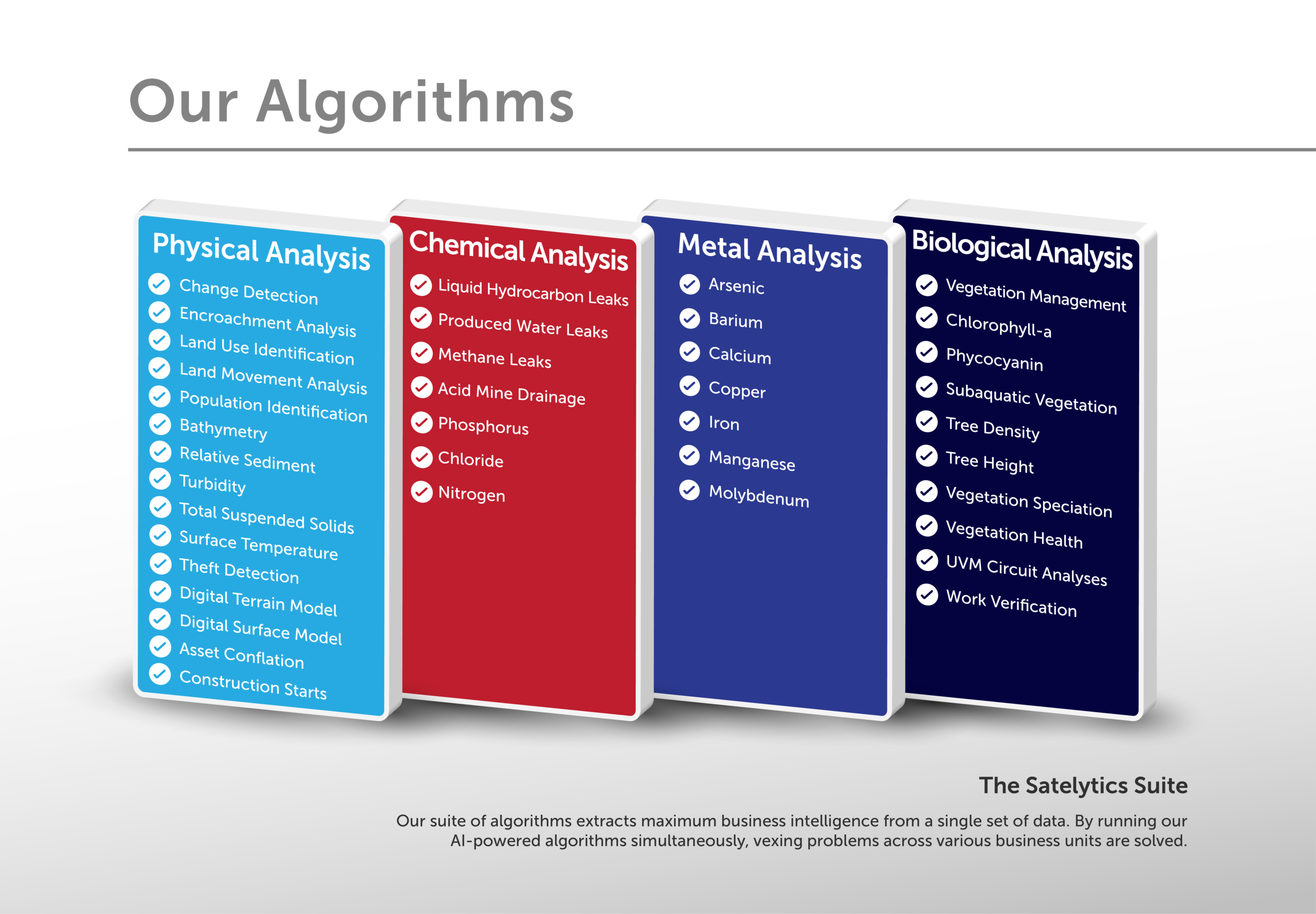
Beachhead on your highest-consequence problem, then expand use of the data.
Match Monitoring Cadence to Real Risk, Not Convenience
With thousands of commercial satellites now in orbit and revisit rates shrinking, the constraint on monitoring frequency is no longer supply; it’s strategic intent. Organizations should set collection cadence based on regulatory deadlines, seasonal risk windows (spring flooding, summer vegetation growth, winter frost heave), and the actual velocity of the threat being monitored. A slow-moving geohazard does not need weekly imagery; an active leak or encroachment site does. Calibrating cadence to risk, rather than defaulting to convenience, is what separates a compliance checkbox from a genuine early-warning system.
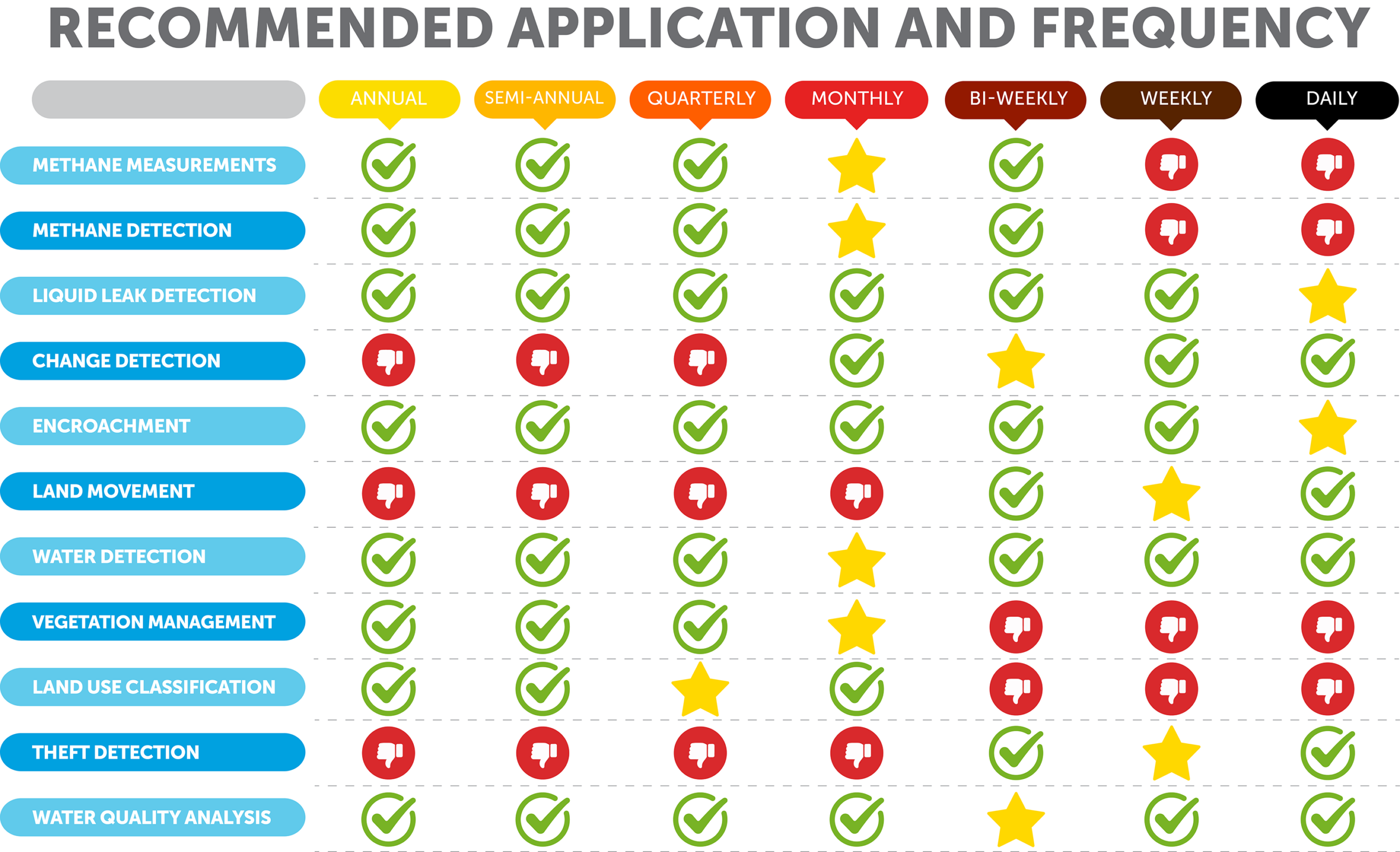
Satelytics’ recommended capture/analysis cadences.
Prove Value in a Contained Area Before Scaling
Even though AI-driven analytics scale effortlessly across cloud infrastructure, disciplined programs still start with a defined, high-confidence pilot area. This lets teams validate detection accuracy, establish response workflows, and build muscle memory before expanding coverage to an entire network. The goal of a proof of concept is organizational rehearsal (not just technical validation) for how alerts will be triaged, verified, and acted upon at scale.
Treat the Post-Contract Phase as the Real Implementation
Signing a contract is the beginning of the work, not the end. Long-term value depends on two factors that have nothing to do with satellites: visible executive commitment and rigorous performance measurement. Leadership must proactively frame GeoAI adoption as an amplifier of field expertise, not a replacement for it. The real win is freeing personnel from unproductive manual scouting and directing them to verified, high-priority locations where their judgment adds the most value. This reframing matters given that AI change-management research consistently identifies skills gaps and workforce anxiety, not the technology itself, as the leading barrier to adoption.
Build a Two-Way Performance Scorecard
Accountability should run in both directions. The strongest implementations pair a vendor performance scorecard with metrics measuring how effectively the customer’s internal teams use the data (e.g., alert response times, field validation accuracy, and measurable risk mitigation outcomes). This joint scorecard builds an internal business case that justifies continued investment while surfacing process gaps on the customer side before they erode program value. Organizations piloting this approach with large-scale geospatial programs have used it to demonstrate tangible ROI while identifying where internal workflows needed adjustment.
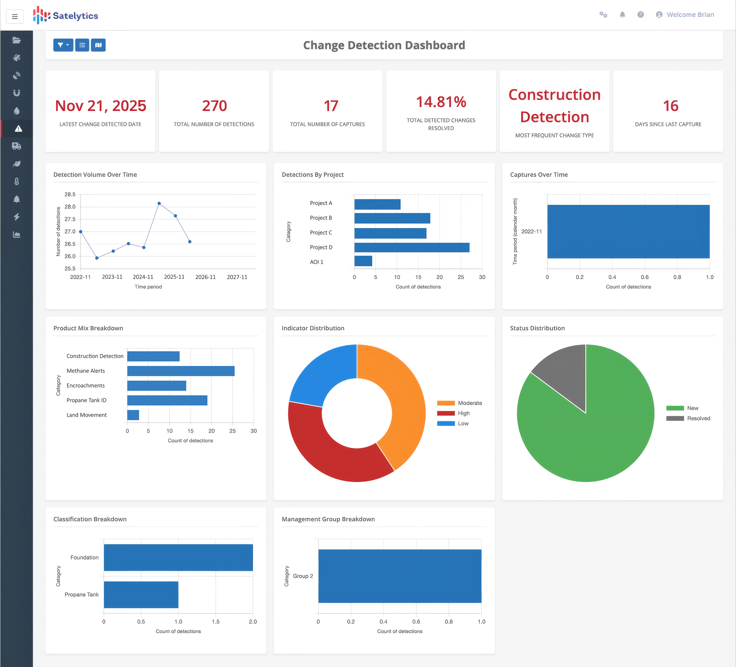
Typical satelytics.io dashboard.
What Maximum-Benefit Adoption Looks Like Across the Organization
- Operations/field teams: Shift from broad manual scouting to targeted verification of AI-flagged anomalies, increasing time on high-value judgment work.
- Compliance/regulatory affairs: Use satellite-derived, timestamped evidence to support frameworks like OGMP 2.0 and demonstrate proactive risk management.
- Executive leadership: Champion adoption publicly, reframe GeoAI as workforce amplification, tie program metrics to enterprise risk and ESG reporting.
- IT/data teams: Integrate geospatial alerts into existing asset management and GIS systems rather than running them as a siloed tool.
- Finance/procurement: Track scorecard-driven ROI metrics to justify scaling coverage beyond the initial pilot area.
The Cost of Waiting
With Earth observation capacity expanding by more than a thousand new satellites over the next several years, and analytics platforms increasingly embedding machine learning directly into data delivery, operators who treat this as standard infrastructure now will simply have more historical baseline data, better-trained detection models, and more mature internal workflows than those who wait. Given that pipeline incident rates have shown no meaningful improvement over the past decade despite substantial investment in traditional inspection methods, and regulatory frameworks are actively building satellite-derived data into compliance pathways, the strategic risk has quietly flipped. It is no longer risky to adopt geospatial analytics: it is increasingly risky not to do so.
Implementing GeoAI successfully is not about acquiring a new sensor. It is about building the organizational muscle needed to convert a now-ubiquitous data stream into a durable operational advantage.