
- Problem: Lost methane = lost revenue.
- Solution: Stop leaks, small and early
- Benefit: Increased revenue
The numbers are sobering. Researchers estimate there are more than 630,000 active leaks in U.S. natural gas distribution mains at any given time, collectively contributing roughly 7.6% of the country’s total methane emissions. The gas industry loses an estimated $195 million worth of natural gas per year to distribution leaks alone. Because methane is 84 times more potent than CO₂ over a 20-year timeframe, those losses carry climate consequences that dwarf their dollar value. For local distribution companies (LDCs) managing tens of thousands of pipeline miles, the status quo is unsustainable financially, environmentally, and increasingly, regulatorily.
The question is no longer whether to modernize leak detection. PHMSA’s landmark Advanced Leak Detection and Repair Final Rule, transmitted to the Federal Register in January 2025, makes that question moot. The rule updates decades-old survey requirements to mandate written Advanced Leak Detection Programs (ALDPs), increases survey frequency, and requires operators to use commercially available advanced technologies capable of identifying, locating, and categorizing leaks that pose hazards to human safety or the environment. PHMSA estimates the rule will deliver up to $1.5 billion in annual net benefits and eliminate up to 500,000 metric tons of methane from approximately 2.8 million miles of gas infrastructure across the United States.
The race is on. And a large gas utility operating in the southeastern U.S. may have already won it.
The Old Way Was Never Good Enough
Legacy leak detection is a labor-intensive, time-compressed, geographically incomplete exercise. Federal regulations under 49 CFR §192.723 require distribution lines outside business districts to be surveyed at intervals of at least once every five years, while unprotected lines must be surveyed every three years. For a utility operating tens of thousands of pipeline miles across multiple states, that schedule means a technician walking your neighborhood with a handheld instrument might not pass by for half a decade. That is plenty of time for a slow-seeping leak to become a significant emissions source or, in worst-case scenarios, a safety event.
Vehicle-based surveys offer incremental improvement but remain constrained by road access, weather, and the sheer number of survey-miles required. Many customers have reported to Satelytics that a single vehicle-based program can take months to survey one distribution area. Handheld instruments go where roads don’t, but they also introduce issues of private property access, vegetation obstruction, and plain human fatigue.
Meanwhile, emissions reporting based on population and pipe-age factors rather than direct measurement failed to give utilities accurate pictures of their actual emissions footprint. Regulators, investors, and environmental stakeholders were growing impatient. The old way was never quite good enough, and the industry knew it.
A Fundamentally Different Approach
In 2021, a large gas utility in the southeastern U.S., serving more than a million customers across multiple states and operating approximately 35,000 miles of pipeline infrastructure, partnered with Satelytics to pursue what both organizations described as an “industry pathfinder” for better methane detection. The mission was straightforward: use satellite-based geospatial analytics to find leaks across a vast network, faster and more completely than any ground-based method could.
The technology at the heart of the program is shortwave infrared (SWIR) satellite imagery analyzed by Satelytics’ proprietary AI-powered algorithms. When methane is present in a plume above a pipeline, it absorbs specific wavelengths of infrared light in a distinctive spectral signature. Satelytics’ algorithms identify those signatures in high-resolution satellite imagery captured by commercial satellites such as Maxar’s WorldView-3 and translate them into precise, actionable alerts: GPS coordinates, estimated flow rates, and concentration gradients, delivered to field teams within hours of a satellite pass.
The spatial resolution is 3.7 meters, allowing pinpoint identification of leaks down to individual meter sets, risers, and service connections. And critically, the system’s minimum detection threshold is 1 kilogram of methane per hour, a level of sensitivity that is roughly 100 times more precise than the emissions-floor of many NGO-operated satellite monitoring platforms, which typically cannot identify sources below 100 kg/hr. What satellites see from orbit that legacy surveys miss on the ground is not a matter of perspective. It’s a matter of physics, spectral resolution, and AI.
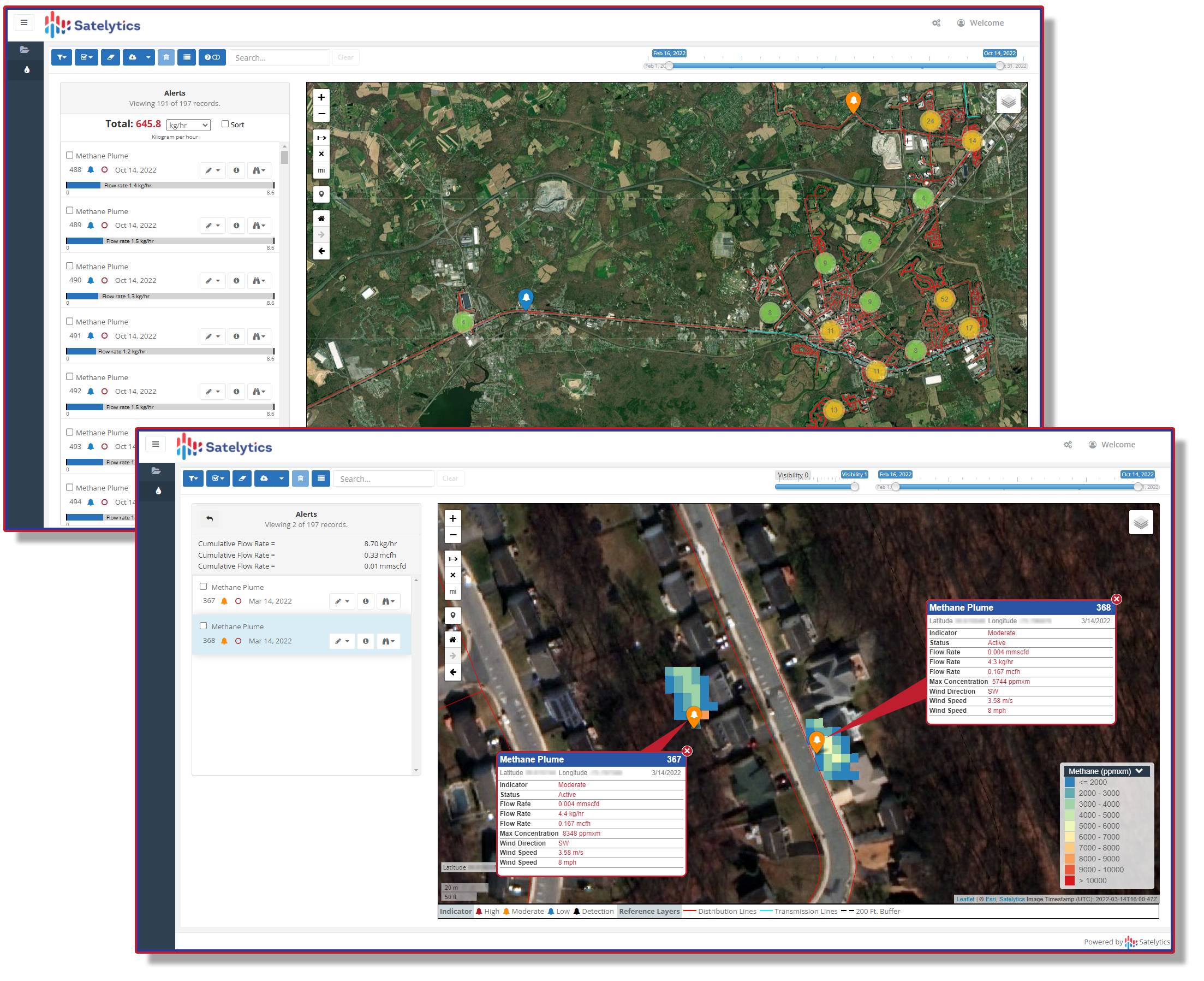
High-resolution imaging enables the identification of close plumes.
The Partnership Model: Technology Is Only Half the Equation
Here is where the story becomes instructive for any LDC considering this path: the satellite is not a silver bullet. Satelytics delivers an alert. What happens next is entirely a function of the utility’s operational culture, field workflows, and, most fundamentally, its willingness to redesign how work gets done.
When the southeastern utility first deployed Satelytics’ system in North Carolina, early results highlighted a challenge that satellite analytics alone could not solve. An initial scan detected 433 methane plumes, with a field verification accuracy rate of roughly 70%. That number (impressive by any comparison to legacy methods) was nevertheless a starting point, not a finish line. It required both parties to lean into it.
On Satelytics’ side, that meant continuous refinement of the AI-powered algorithms, incorporating field feedback to tune the detection model to the local variables impacting alert accuracy for the southeastern network. On the utility’s side (and this is critical), it meant something far more organizationally difficult: rewriting standard operating procedures.
The utility and its field services partner developed a new dedicated workflow — an alert-driven process called “Pinpoint, Assess, Repair,” or PAR — that structured field crew behavior around satellite-derived alerts rather than scheduled patrol routes. Instead of waiting for a patrol to be scheduled and executed, crews were dispatched to satellite-identified coordinates. Instead of completing a survey route and filing a report, technicians arrived at a specific location with a specific problem to investigate. The rhythm of operations shifted from calendar-driven to intelligence-driven.
The results of that commitment were immediate. Over thousands of leak alerts, field crews found a confirmed plume approximately 70% of the time within 150 feet of the satellite-provided coordinates. Extending the search radius to 400 feet pushed verification accuracy above 95%.
The SOP Imperative: Commit or Don’t Start
The SOP transformation is not a footnote to this story; it is the story. Satelytics can deliver a satellite alert within hours of a pass. It can pinpoint a leak to within a few meters. It can quantify flow rates, generate work orders, and integrate with field management systems. But if the utility on the other end is still routing those alerts through a legacy scheduling queue, triaging them against a decades-old priority matrix, and waiting for the next planned patrol cycle to verify them, the satellite’s value evaporates before it reaches the field.
LDCs that have succeeded with this program share a common trait: they treated the partnership as a mandate to reimagine field operations from the alert backward. Those that have integrated satellite alerts as the primary trigger for leak investigation, replacing or substantially subordinating traditional patrol schedules, have seen dramatic results. Those that have attempted to layer satellite data on top of unchanged legacy workflows without modifying their SOPs have, almost universally, struggled to realize the technology’s potential.
The lesson is unambiguous: the satellite finds the leak. The SOP determines whether it gets fixed.
Results That Speak for Themselves
The southeastern utility’s commitment to operational transformation has produced outcomes that have drawn national attention.
Since the beginning of 2022, the utility has reduced its backlog of recordable leaks by more than 85%. In 2023 alone, its North Carolina operations investigated 13,668 satellite-identified plumes, achieving a 63% methane detection rate and generating 7,558 leak conditions for repair — with 792 leaks fixed on the very first field visit through the “Find It / Fix It” model. The average time to repair a confirmed leak fell dramatically, reaching just 20 days by mid-2024.
This performance earned the program validation at the highest levels. In March 2023, the U.S. Department of Energy’s Office of Fossil Energy and Carbon Management awarded the utility nearly $1 million in federal funding to extend the platform upstream to pipeline suppliers and downstream to large-scale customers. The utility’s program has since been cited as a model for what satellite-enabled methane monitoring can accomplish at scale.
Perhaps the most remarkable headline: driven by the program’s success, the utility has accelerated its net-zero methane emissions target by 15 years, from 2050 to 2035.
Beyond Leak Detection: A Platform, Not a Project
Utilities that invest in geospatial infrastructure for methane detection often discover that the real value extends far beyond the original use case. The satellite imagery and AI processing pipeline built for leak detection can be simultaneously aimed at entirely different business challenges with near-zero marginal cost per additional algorithm engaged.
The southeastern utility has used the same satellite data streams for new construction monitoring, identifying residential and commercial building starts across the service territory to proactively plan service line extensions rather than waiting for customer applications. A related application leverages change detection to identify properties currently served by propane tanks that could be converted to natural gas service, thus turning Satelytics into a customer acquisition tool.
This is the architecture of a modern geospatial analytics platform: not a one-time project, but a persistent intelligence layer over the utility’s entire physical footprint.
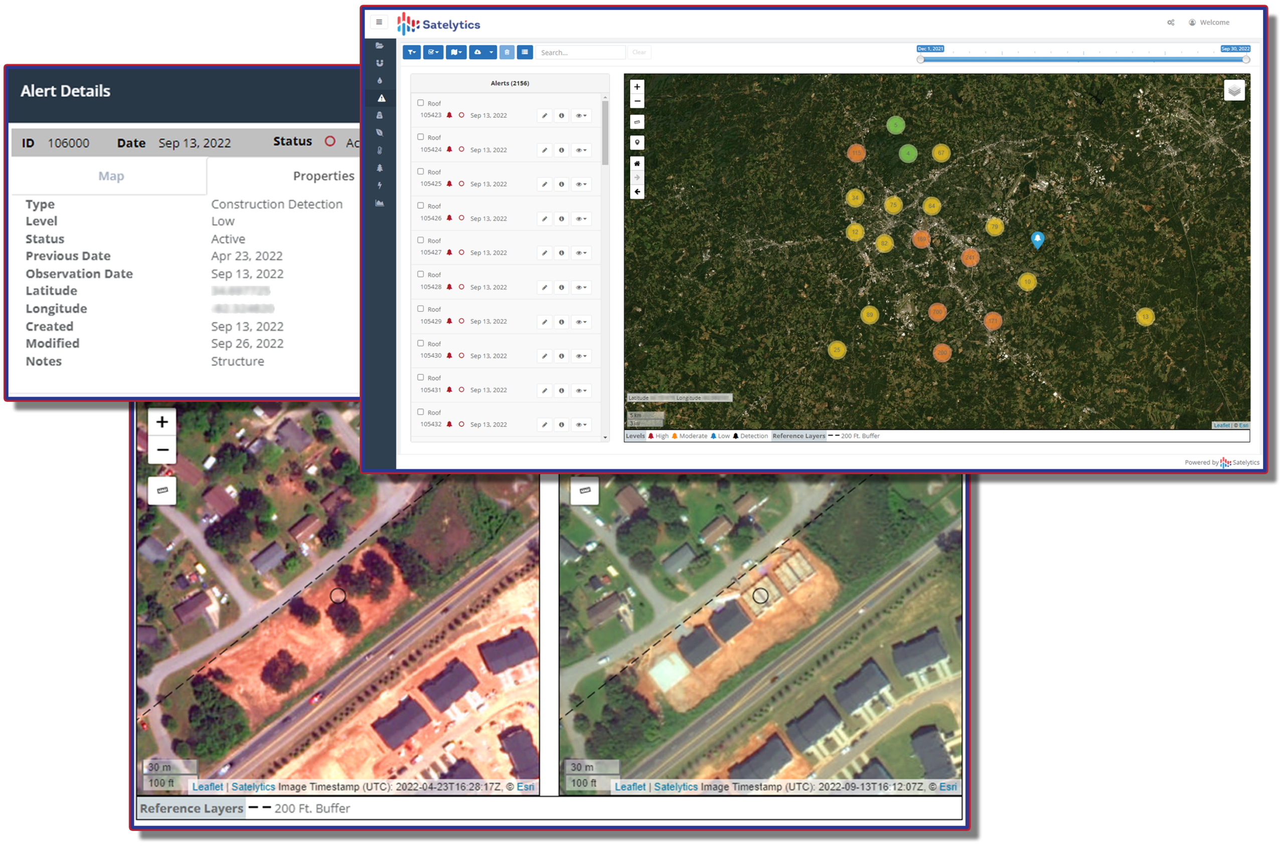
Identifying new construction before the developer alerts the utility.
The Regulatory Horizon Is Not Optional
PHMSA’s Advanced Leak Detection and Repair Rule has eliminated the luxury of a wait-and-see posture. The rule’s mandate is clear: operators must establish written Advanced Leak Detection Programs, conduct surveys at increased frequency using commercially available advanced technologies, and demonstrate empirical measurement-based emissions performance.
LDCs that begin this journey now — building the satellite detection capability, retraining field crews, and redesigning SOPs around alert-driven workflows — will be ahead of the compliance curve and, more importantly, ahead of the emissions curve. Those that wait to be compelled will spend the first years of their program catching up to where proactive utilities already stand.
The southeastern utility’s operating philosophy, as described by its own leadership, distills the model to its essence: find the leaks, fix them, wait for the next pass, find the new ones, fix those too. A continuous, intelligence-driven cycle. Not a five-year patrol schedule. Not a factor-based emissions estimate. A real-time, measurable, defensible record of a utility doing exactly what it said it would do.
That is the standard. Satelytics is ready to help you meet it.