
- Problem: Multi-tiered threats to assets.
- Solution: Multi-tiered defense-in-depth.
- Benefit: 100% armor.
We hear it from pipeline operators across the country: you are not relying on a single method to meet your PHMSA monitoring obligations. You are doing all of it. Foot patrols. Aerial flights. Drones. And increasingly, satellite. This is not redundancy for its own sake — it is sound operational strategy. The regulatory framework demands it, the geography of America’s pipeline network requires it, and hard-won experience has proven that no one tool catches everything.
Satelytics is not here to replace any method in your monitoring stack. We are here to make every other method more effective. This article explains where PHMSA’s requirements for liquid leak detection and right-of-way (ROW) encroachment specifically obligate you to act — and how satellite-based geospatial analytics fits, with precision, into the multi-layered approach you are already running.
The Regulatory Foundation: What PHMSA Requires
Federal pipeline safety regulations set clear, non-negotiable expectations for operators of hazardous liquid pipelines on two fronts that satellite analytics directly addresses: leak detection and ROW patrol.
Liquid Leak Detection: 49 CFR § 195.134 and § 195.444
As of October 2024, all onshore hazardous liquid pipelines transporting single-phase liquid must have a compliant leak detection system in place under 49 CFR § 195.134. This was not a soft guideline; it was a hard deadline with enforcement consequences.
The companion regulation, § 195.444, requires operators not simply to have a leak detection system, but to evaluate and document its capability, ensuring it can detect leaks promptly and effectively. This distinction matters enormously. PHMSA is not asking whether you have a system on paper. It is asking whether your system actually works, and whether you can prove it.
The Known Limitation: What SCADA and CPM Miss
The dominant internal leak detection tool in North American operations is Computational Pipeline Monitoring (CPM) built atop SCADA infrastructure. It is powerful, but bounded. SCADA-based CPM systems struggle to detect leaks below roughly 1% of pipeline throughput, and their performance degrades further during non-steady-state operating conditions: startups, shutdowns, batch transitions, pressure transients. A breach that slowly grows from a hairline crack to a reportable release may be essentially invisible to a CPM system until it becomes a major event. Small, chronic seepage (exactly the kind of contamination that creates the most costly long-term remediation liability) often evades internal detection entirely.
Satellite-based geospatial analytics approaches leak detection from the outside in, which means it operates independently of pipeline operating conditions. It detects surface manifestations of liquid releases directly, and it detects the biological consequences of subsurface contamination before any liquid reaches the surface, through vegetation stress analysis. This is not a substitute for § 195.134 compliance. It is a complementary layer that catches what internal systems routinely miss.
ROW Patrols: 49 CFR § 195.412
For hazardous liquid pipelines, § 195.412 sets one of the most demanding patrol schedules in the regulatory framework: operators must inspect surface conditions on or adjacent to each pipeline right-of-way at intervals not exceeding three weeks, at least 26 times per calendar year. The regulation explicitly permits “walking, driving, flying or other appropriate means.”
That phrase, “other appropriate means,” has been the subject of considerable regulatory attention. In July 2025, PHMSA issued a Direct Final Rule (DFR) directly codifying satellite imaging into the text of §§ 192.705(c) and 195.412(a), placing it on equal footing with walking, flying, or driving as an accepted patrol method. The rule was subsequently withdrawn due to adverse comment and reissued as a Notice of Proposed Rulemaking (NPRM) in April 2026, with a comment period open through June 23, 2026.
The direction of regulatory travel is unmistakable: PHMSA is actively formalizing what operators using satellite technology already know to be true. The question of compliance legitimacy is not whether, but rather when, the final rule will codify what the DFR already established.
For parallel gas transmission pipelines, § 192.705 establishes patrol requirements on a population-density-dependent schedule, and the same “other appropriate means” language applies.
ROW Encroachment: The Specific Threat the Regulations Address
Encroachment is any activity, structure, or improvement (temporary or permanent) on or near a pipeline right-of-way that could adversely affect pipeline integrity, operation, maintenance, or safety. PHMSA’s PIPA Recommended Practice BL13 makes the operator’s obligations explicit: detect encroachments, document them, communicate with the encroaching party, enforce your policy diligently and consistently, and maintain written records. These obligations are grounded in §§ 195.410, 195.412, 192.705, and 192.707.
The stakes are not theoretical. Approximately 80% of all pipeline accidents are caused by impacts from digging or excavation activity, making third-party encroachment the single largest external cause of pipeline failure. From 2005 through 2016 alone, there were 875 reported major pipeline incidents caused by excavation damage, resulting in 40 fatalities and 166 serious injuries. A pipeline catches fire every four days and results in an explosion every eleven days in the United States, with hazardous liquids pipelines responsible for 64% of incidents and 64% of damages, despite accounting for less than 8% of total pipeline mileage.
The economics of third-party damage are severe. Even a single undetected encroachment that results in a delayed-release incident can generate far greater liability than years of proactive monitoring investment. The key variable is detection timing: finding construction activity in its early stages is categorically different from discovering a completed barn or parking lot that has already compromised safety clearances.
Where Satelytics Fits and What We Add
The Strategic High Ground: Basin-Scale Awareness at Patrol Frequency
The § 195.412 mandate requires 26 ROW inspections per year. For an operator managing thousands of miles of gathering lines threading across remote terrain, meeting that cadence with boots on the ground or helicopter sorties is expensive, labor-intensive, and operationally difficult. Satellite monitoring changes the economics fundamentally. Weekly satellite-derived intelligence can fulfill the broad-area surveillance function of the patrol requirement at a fraction of the cost, freeing aerial and ground assets to focus precisely where the satellite has flagged a potential issue.
This is not theoretical. In the Williston Basin, where more than 1.2 million barrels of oil per day flow through tens of thousands of miles of gathering lines across remote prairie, a leading operator contracted Satelytics for weekly basin-wide monitoring following a catastrophic 34,000-barrel produced water release that went undetected for nearly a month. The program has since identified dozens of confirmed crude oil and produced water leaks at their earliest stages, often before SCADA alarms, field crews, or routine inspections detected anything. Several early detections were documented in North Dakota DEQ HazConnect database reports with Satelytics specifically cited as the initial detection agent.
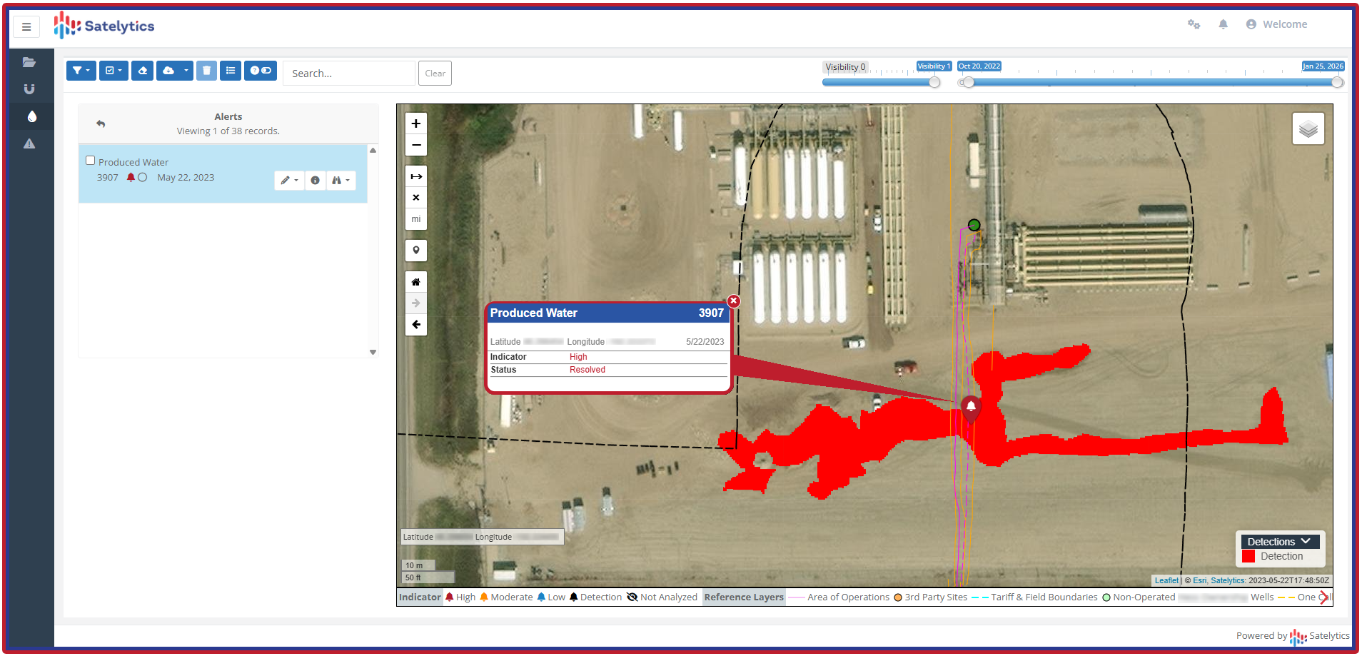
Liquid leak alerts, including produced water.
Liquid Leak Detection: Finding What Internal Systems Miss
The compliance obligation under § 195.134 and § 195.444 is to have an effective, documented leak detection system. But PHMSA’s own research acknowledges that current CPM systems cannot reliably detect leaks below 1% of pipeline throughput, particularly during non-steady-state conditions. The history of major liquid pipeline incidents is, in part, a history of leaks that fell below internal detection thresholds for days or weeks before discovery.
Satelytics addresses this gap through two independent detection pathways operating simultaneously:
- Direct surface detection: AI-powered multispectral analysis identifies the spectral signature of hydrocarbons and produced water on the surface, detecting a release at or near the point of origin, not after it has migrated to a reportable threshold.
- Vegetation stress analysis: Subsurface contamination causes measurable changes in plant health before any liquid reaches the surface. In ten documented cases in the Williston Basin program, satellite-derived vegetation stress analysis identified underlying gas releases. These same fugitive emissions went undetected by all conventional methods. The same biological indicator pathways apply to liquid contamination seeping into root zones.
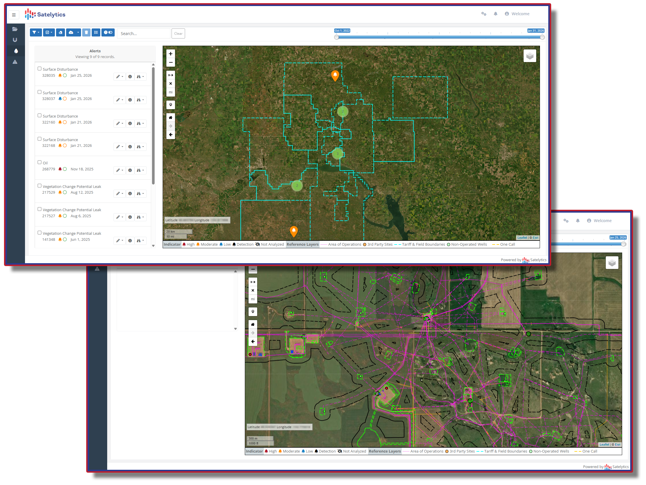
Basin-scale awareness, weekly.
ROW Encroachment: Find It While It Can Still Be Fixed
The Southern Company experience illustrates the central challenge of encroachment monitoring at scale. Thousands of miles of right-of-way. Service territory inspected only every few years in some locations. Encroachments that often begin with land disturbances (cleared vegetation, graded earth, etc.) weeks before any structure appears. The window to intervene, when moving a partially-built barn costs a phone call rather than a lawsuit, is narrow.
Satelytics’ change-detection algorithms identify land disturbances that precede construction, flagging the cleared ground and altered land use patterns that signal an encroachment is forming, not one that has already solidified. High-resolution satellite imagery provides sufficient detail to measure how far an encroachment penetrates into the right-of-way, enabling operators to distinguish between minor technical violations and genuine safety hazards. During the Southern Company pilot, AI-generated alerts were refined through operator feedback to flag only those encroachments that posed real danger or operational problems, demonstrating the ongoing learning capability of the platform.
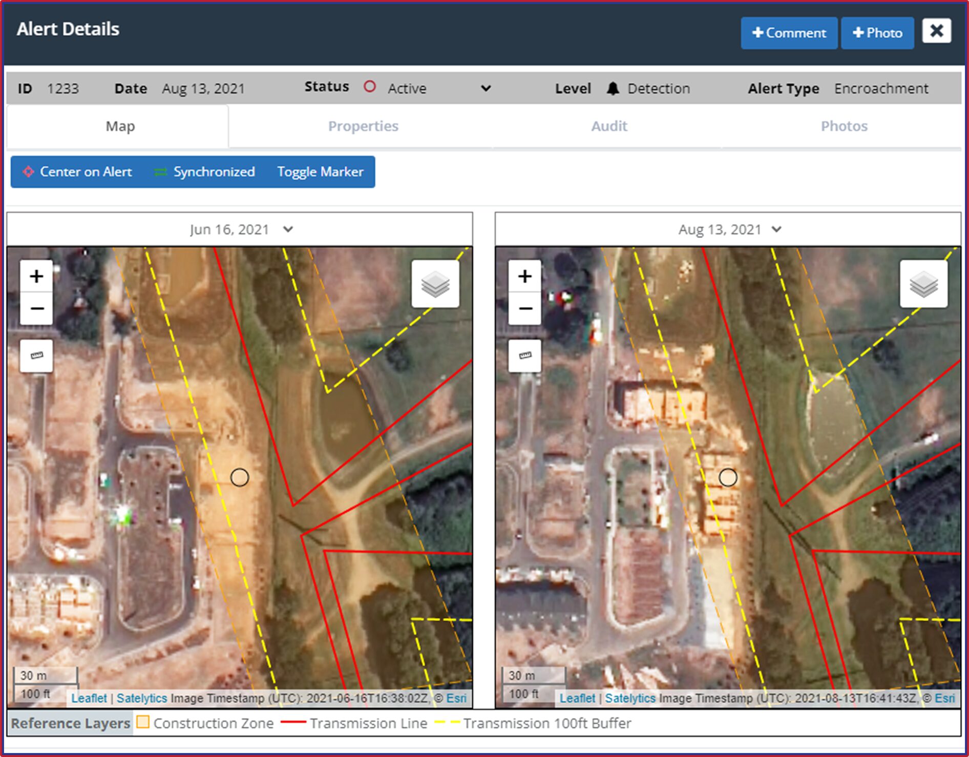
Right-of-way encroachment caught early.
The Multiplier Effect: Making Every Other Resource More Effective
The traditional monitoring methods operators rely on are not being displaced by satellite analytics. They are being aimed better. Satelytics identifies the 5–10% of network segments where problems are most likely to be developing. Ground crews and drone operators don’t respond to a 300-mile corridor. They respond to a 2-mile segment with a confirmed anomaly. Aerial teams aren’t flying speculative patterns. They are verifying a satellite-flagged surface disturbance. SCADA operators aren’t chasing noise in a CPM alarm. They’re cross-referencing an independent detection from orbit.
The result is a monitoring architecture where each layer reinforces the others. Satellite analytics provides the wide-area awareness. Ground and aerial methods provide the close-in verification. Internal CPM/SCADA provides the real-time flow and pressure baseline. No single method has to do everything, because no single method can.
Beyond Compliance: The Operational and Strategic Case
- Reduced false-positive burden. Traditional monitoring systems can generate false positive rates that consume 30% of operational teams’ workdays. Satellite analytics, by providing broad contextual data about surface conditions across an entire corridor, helps distinguish genuine threats from benign anomalies, directing ground response to real events rather than artifacts.
- Methane and emissions visibility. The same platform that monitors liquid releases can deploy methane measurement capabilities, giving operators an independently managed tool for large-scale emissions gauging. This serves as a valuable cross-check against internal inventories as methane reporting requirements under NSPS OOOOb/OOOOc remain on the books despite recent legislative changes.
- Documented environmental vigilance. In an era of increasing regulatory scrutiny and landowner sensitivity, an auditable, time-stamped record of weekly basin-wide monitoring is a tangible demonstration of good-faith environmental stewardship. When a release does occur, the operator with documented early-detection records and rapid response evidence is in a categorically different position with regulators, courts, and communities than the operator who was relying on a quarterly aerial flyover.
- Scalable economics. Unlike ground-based surveillance, satellite monitoring costs do not scale linearly with the miles monitored. An operator who expands its gathering system does not proportionally expand its satellite monitoring budget. This characteristic makes comprehensive coverage economically viable even across the vast, geographically dispersed networks that characterize Permian, Bakken, and Marcellus operations.