
- Problem: Insight after chaos of storm/war.
- Solution: Quick analysis of satellite data.
- Benefit: Quick insights not obtainable any other way.
When fighting breaks out or storms hit, critical infrastructure becomes fragile in a hurry. Tanks rupture, pipelines are damaged, and ships take hits. In the Persian Gulf, that can mean oil and other liquids spreading quickly across some of the world’s busiest shipping lanes and most sensitive coastlines.
This month, we used freely available European Sentinel-2 satellite images to look at recent incidents in and around Iran. Our goal was simple: turn raw satellite data into clear pictures decision-makers can understand in seconds, not hours.
What We Analyzed
We examined several areas in and around the Strait of Hormuz because it has been a focal point of hostilities and is also a focal point of energy infrastructure. Lavan Island and nearby waters are home to a refinery and sensitive marine environments.
At Lavan Island on April 10, public reports spoke of an attack on the refinery. In our analysis, we identified a mappable oil slick on the water.
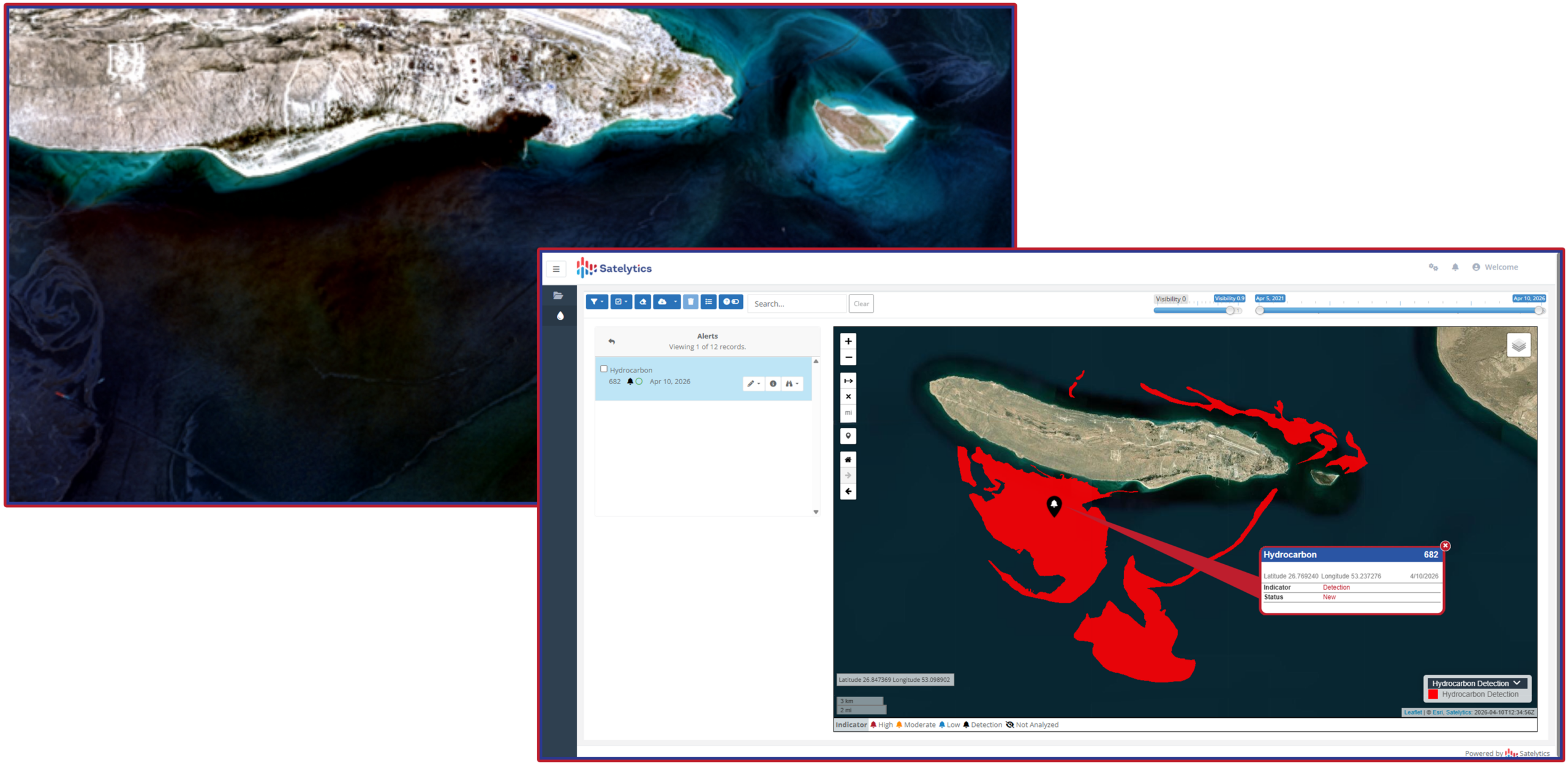
Oil slick identified after hostilities near Lavan Island.
How We Turned Raw Pixels into Quick Insight
Raw satellite imagery is not “boardroom-ready.” Left untouched, it can be noisy, low-contrast, and hard to interpret for anyone who isn’t a remote sensing specialist.
Here’s what Satelytics did with open Sentinel-2 data:
- Sharpened the imagery using AI so that buildings, ports, reefs, and surface features stand out more clearly, even though the original data is lower resolution.
- Adjusted contrast across the image so that thin oil films, slicks, smoke, and shoreline details are easier to see with the human eye.
- Built focused “plume views” around smoke features, smoothing and normalizing the pixel values so stakeholders can quickly see where the plume is strongest without needing to interpret raw numbers.
The result: a set of graphics that a non-technical lead can glance at once and immediately understand what’s happening and where. Instead of scrolling through raw satellite scenes or waiting for long-form reports, they get fast, visual answers to questions like:
- Is there something on the water, and how big is it?
- How close is it to coasts, islands, or key facilities?
- Is the main concern oil on the surface, smoke in the air, or damage on land?
Why This Matters During Crises
In a war zone or after a major storm, traditional inspections can be slow, dangerous, or outright impossible. Aircraft may not be allowed into the area, and sending people on the ground can put crews at risk. Satellite data, on the other hand, can cover huge areas in a single pass and can be analyzed within hours.
Satelytics is built to turn that fresh satellite imagery into rapid, actionable answers:
- Where are the leaks, spills, or smoke plumes today?
- Which assets, coastlines, or communities are most at risk right now?
- Where should limited repair and response resources go first?
Our work in the Gulf this April shows how open data can be transformed into a practical disaster and conflict monitoring tool. One package, built from a couple of satellite scenes, delivered two different—but complementary—views: visible oil on water where the pixels support it, and smoke and land-based damage where that’s the clearer signal.
A Realistic, Responsible View
Satellite images are powerful, but they are one part of a larger picture. Optical data alone cannot prove exactly what substance is in the water, who is responsible, or what the chemistry looks like on the ground. Sun glare, clouds, and sensor limits still matter, and serious decisions should combine multiple dates, different types of satellite data, and any on-the-ground or aerial reporting available.
Even with those caveats, the value is clear. In a world where infrastructure can be damaged overnight—by conflict or by nature—fast, wide-area visibility is no longer a luxury. It is essential for protecting people, the environment, and the energy systems we all depend on.
Satelytics exists to provide that visibility: turning complex satellite data into immediate, understandable insight when it matters most.